United States Space Surveillance Network
The United States Space Surveillance Network (SSN) detects, tracks, catalogs and identifies artificial objects orbiting Earth, e.g. active/inactive satellites, spent rocket bodies, or fragmentation debris.
The continued increase in satellite and orbital debris populations, as well as the increasing diversity in launch trajectories, non-standard orbits, and geosynchronous altitudes, necessitates continued modernization of the SSN to meet existing and future requirements and ensure their cost-effective supportability.
There is an Image Information Processing Center and Supercomputing facility at the Air Force Maui Optical Station (AMOS).
known as the National Space Surveillance Control Center (NSSCC), located at Hanscom Field in Bedford, Massachusetts.
In 1960, under Project Space Track, Fitzpatrick and Findley developed detailed documentation of the procedures used at the NSSCC.
Early Space Track observations of satellites were collected at more than 150 individual sites, including radar stations, Baker–Nunn cameras, telescopes, radio receivers, and by citizens participating in the Operation Moonwatch program.
These systems used modified Schmidt telescopes of great resolution to photograph and identify objects in space.
The Baker-Nunn system, like Minitrack, provided little real-time data and was additionally limited to night-time, clear weather operations.
The amount of satellite tracking data accumulated required creation or expansion of organizations and equipment to sift through and catalog the objects.
The need for real-time detection and tracking information to deal with Soviet satellite launches led on 19 December 1958 to ARPA's implementation of Executive Order 50-59 to establish a spacetrack network.
ARDC took up the spacetrack mission in late 1959 and in April 1960 set up the Interim National Space Surveillance Control Center at Hanscom Field, Massachusetts, to coordinate observations and maintain satellite data.
Additional sensors that performed or contributed to space tracking but are not yet included in this page include mechanical tracking radars on the islands of Kaena Point, Antigua, Ascension Island, Naval Station San Miguel, and Kwajalein Atoll; the three BMEWS sites; the Pave Paws sites; the AN/FSS-7 missile warning radar sites; the Passive electronically scanned array sites; Cavalier, ND; Eglin, FL; Maui Space Surveillance System; Globus II; San Vito dei Normanni Air Station; TOS/CROSS; and MIT Lincoln Laboratory.
The orbital elements and their associated partial derivatives are expressed as series expansions in terms of the initial conditions of these differential equations.
Assumptions must be made to simplify these analytical theories, such as truncation of the Earth's gravitational potential to a few zonal harmonic terms.
Becoming operational in 1977, Cobra Dane also had a primary mission of monitoring Soviet tests of missiles launched from southwest Russia aimed at the Siberian Kamchatka peninsula.
Although limited by their mechanical technology, Pirinclik's two radars gave the advantage of tracking two objects simultaneously in real time.
Its location close to the southern Former Soviet Union made it the only ground sensor capable of tracking actual deorbits of Russian space objects.
General Electric Heavy Military Electronics Division (HMED) in Syracuse, NY was the prime contractor and Lincoln Laboratory was a subcontractor.
After circling the Earth in an apparently dormant state for 9 months, on November 13, 1986 the SPOT 1 Ariane third stage violently separated into some 465 detectable fragments - the most severe satellite breakup yet recorded prior to 2007.
Although the debris cloud did not pass over the continental United States until more than 8 hours later, personnel in the Space Surveillance Center (SSC) at the Cheyenne Mountain Complex in Colorado Springs, Colorado reported that the U.S. FPS-79 radar at Pirinclik, Turkey, noticed the debris within minutes of the fragmentation.
[18] Blue Nine refers to a project which produced the AN/FPS-79 Tracking Radar Set built by General Electric, used with the 466L Electromagnetic Intelligence System (ELINT); US Air Force.
[19] As of June 23, 2019[update], the catalog built using SSN data listed 44,336 objects including 8,558 satellites launched into orbit since 1957.
The SSN typically tracks space objects which are 10 centimeters in diameter (baseball size) or larger.
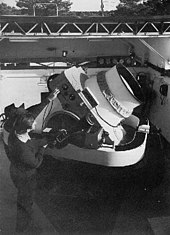
Ground-based Electro-Optical Deep Space Surveillance, or GEODSS, is an optical system that uses telescopes, low-light level TV cameras, and computers.
It replaced an older system of six 20 inch (half meter) Baker-Nunn cameras which used photographic film.
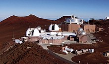
Moron Optical Space Surveillance (MOSS), a transportable 22-inch aperture telescope that contributed to the GEODSS system was operational at Morón Air Base, Spain 37°10′12″N 5°36′32″W / 37.170°N 5.609°W / 37.170; -5.609 from 1997 to 2012.
This sensitivity, and sky background during daytime that masks satellites reflected light, dictates that the system operate at night.
As with any ground-based optical system, cloud cover and local weather conditions directly influence its effectiveness.
In 2010, USSTRATCOM was given authority to provide SSA (Space Situational Awareness) services to commercial and foreign actors.