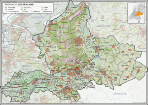
Gelderland
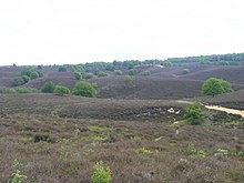
[2] It contains the Netherlands's largest forest region (the Veluwe), the Rhine and other major rivers, and a significant amount of orchards in the south (Betuwe).
Historically, the province dates from states of the Holy Roman Empire and takes its name from the nearby German city of Geldern.
Thus the counts of Guelders laid the foundation for a territorial power that, through control of the Rhine, Waal, Meuse and IJssel rivers, was to play an important role in the later Middle Ages.
The geographical position of their territory dictated the external policy of the counts during the following centuries; they were committed to the interests of the Holy Roman Empire and to expansion south and west.
Further enlarged by the acquisition of the imperial city of Nijmegen in the 13th century, the countship was raised to a duchy in 1339 by the Holy Roman Emperor Louis IV.
The duchy resisted Burgundian domination, but William, Duke of Jülich-Cleves-Berg was forced to cede it to Charles V in 1543, after which it formed part of the Burgundian-Habsburg hereditary lands.
In 1672, the province was temporarily occupied by Louis XIV and, in 1713, the southeastern part, including the ducal capital of Geldern, fell to Prussia.