Haast to Paringa Cattle Track
To avoid the steep cliffs and rugged coastline around Knights Point (an area that was labelled by early diggers "run-or-be-damned") travellers up and down the West Coast would head inland along the Waita and Moeraki Rivers, crossing the low (700 m) Paringa Saddle.
The explorer Charlie Douglas, along with Julies Matthies and a man by the name of McGloin, undertook to clear bush from Lake Paringa to the mouth of the Waita River, the route of the current track.
[4] A road over the Paringa Saddle would be an important connection for the South Westland settlements of Haast, Okuru, and Jackson Bay, which even into the first half of the 20th century were still isolated from the rest of New Zealand.
A ship would arrive every two or three months with supplies, but the land access was via the Haast Pass, a route only suitable for horses, rugged, over 80 km long, and requiring boat transport down Lake Wānaka at the end.
[3] By 1875 mobs of cattle were already being driven from the Arawhata and Cascade river valleys north over the Paringa Saddle—now a shorter and easier alternative to the journey over Haast Pass.
At that point apart from twice-yearly cattle drives the track was mostly used by hunters and trampers; Haast residents preferred to fly to Hokitika.
In 1965 the road north to the glaciers and Hokitika was finished, and there was now a continuous highway loop, bypassing the cattle track, which fell into disrepair.
[5] In 2012 a large slip on near Knights Point raised the possibility of road access to the Haast Pass being eventually cut off.
In the 2023 election campaign, independent candidate Patrick Phelps and National MP Maureen Pugh both raised the idea of rerouting State Highway 6 inland through the cattle track.
[1] The track travels through mixed southern beech/podocarp forest, following the Moeraki River, and crosses a swingbridge to reach Blowfly Hut, an hour and a half from the main road.
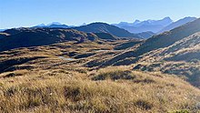
[9] The track from Blowfly Hut to Māori Saddle takes 4.5 hours, travelling southwest uphill through beech/kāmahi forest, following the western edge of the Mataketake Range.
Markers indicate the routes around fallen trees and slips; the track crosses the Alpine Fault and the area is very prone to erosion from heavy rain.
[1] From Coppermine Creek a two-hour walk on flat ground leads to the southern terminus of the track, beside the State Highway 6 bridge over the Waita River, 11 km north of Haast.
[4] Travel writer A. Maud Moreland stayed in the Blue River hut around 1909, and was plagued by mosquitoes: It was nothing but a corrugated-iron box, eight or nine feet square, with a rude bunk, covered with fern, at either side; between them was a dirty cupboard smeared with candle grease, which served as a table; a stool by the wide hearth and two old billies completed the furniture.