Halle (Westfalen)
Halle is situated on the sandy plain of the river Ems on the southern slopes of the Teutoburg Forest, which crosses the town territory from northwest to southeast.
This mountain range delimits the eastern part of the Münsterland and the Westphalian Basin and is the drainage divide between the rivers Ems and Weser here.
As a consequence of historic tillage techniques and long-term agricultural usage these soils are partly composed of deeply rooting humus, in scattered areas with a sod coat.
Some isolated dells are located in south-westerly direction of the main ridge of the Teutoburg Forest, for example the Hesseln mountains.
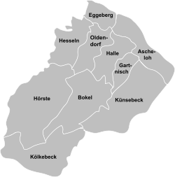
is divided into ten urban districts, of which (besides Halle itself) only the industrial-suburban Künsebeck as well as the rural-agrarian villages Bokel, Hesseln, Hörste and Kölkebeck are built-up areas.
While the rural-agrarian districts can be clearly distinguished as separate parts within the town limits the transition between Halle and Künsebeck is flowing.
The following table gives an overview over the population in the parts of the town:[5] Halle lies in the temperate zone of central Europe.
At the weather station Brockhagen (belonging to Steinhagen (Westphalia)), situated just south of Halle, a yearly total of 775 mm precipitation is recorded on long-term average.
After this nobility also became extinct the county, along with others, came into possession of the house of Kleve-Mark and about a century later, via the Margraviate of Brandenburg, part of the kingdom of Prussia.
The two villages Oldendorf and Gartnisch, today subdivisions of Halle embracing it in the east and west, are older than the present core of settlement.
The Ravensberg rent-roll, finalized in 1556, lists 49 names in Halle between the years 1491 and 1541, thereof 26 free citizens and 23 bondmen of the territorial lord (Landesherr) respectively of the noble landlords in Steinhausen and Tatenhausen.
During this time the Protestant Reformation began in Halle, gradually but largely changing people's religious affiliation.
Temporarily Halle was divided, the border between the French Empire and the Kingdom of Westphalia passed through the town (partly alongside the Laibach creek).
Until well into the 19th century Halle remained largely agrarian- oriented, mainly grain, flax or hemp was cultivated and animal husbandry was run.
Owing to the absorption and integration of a large number of refugees grave economic and demographic shifts were brought about.
Muslims can attend services in the Ayasofya Mosque of the Turkish-Islamic cultural association and additionally Jehovah's Witnesses as well as the Kurdish Yazidi are represented with one parochial bodies each.
[7] Due to the "Bielefeld-law", dating October 24, 1972 the town of Halle was united with the communities of Bokel, Hesseln, Hörste, Kölkebeck and Künsebeck on January 1, 1973.
1 present territory The Community Profile[4] of the North Rhine-Westphalian authority for data processing and statistics typecasts Halle as a "small medium-sized town" and compares it to other cities of that type.
On an Index the average for the type "small medium-sized town" arrived at 115 (1976 = 100), whereas Halle reached 119, in effect roughly 3.5% higher.
As a result of communal elections on August 30, 2009 currently the CDU, the SPD, The Greens, the FDP as well as two independent voters' alliances, the UWG and the STU (agenda party favouring a specific marked-out route for the unfinished motorway) are represented in the Halle town council.
Communal politics are strongly coined by local topics, with one of the major issues of the voters being the future dealing with the Bundesautobahn 33 (see below).
In the foreground the heart sign shows the coat of arms of the County of Ravensberg (three red chevrons on silver).
It was granted for the first time in 1908 by order of the King of Prussia, continued to be used unchanged after the incorporations of 1973.The town twinning between Halle and Ronchin (France) dates back to September 22, 1984.
Namely paintings during adolescence of artists like Paul and Felix Klee, August Macke, Ernst Ludwig Kirchner and Pablo Picasso are in the focus of the museum's work.
In many cases international celebrities of classical music can be engaged (Peter Schreier, Thomas Quasthoff, Petr Eben a.o.).
In 2007 the Gerry-Weber-Stadium, which is the 2nd- biggest stadium in the district of Gütersloh, hosted several matches of World Men's Handball Championship.
)", "Künsebeck", "Halle Gerry-Weber-Stadion" and "Hesseln" are located alongside the railway tracks of the Haller Willem (KBS 402).
Halle has a car-free zone which is host to the weekly market and hikers find a choice of twelve signposted circular routes.
There is a choice of four regional commercial airports within one to one and a half hours, thus the number of destinations that can be reached with a direct flight is quite high.
The most renowned employers in Halle are: The Haller Kreisblatt, a cooperation partner of the Neue Westfälische, and a local edition of the Westfalen-Blatt are published as daily newspapers Monday through Saturday with a comparable number of copies.


lower line: respective territory