Hampi
Chronicles left by Persian and European travellers, particularly the Portuguese, say that Hampi was a prosperous, wealthy and grand city near the Tungabhadra River, with numerous temples, farms and trading markets.
[3][5][9] Located in Karnataka near the small modern town of Hampi with the city of Hosapete 13 kilometres (8.1 miles) away, Hampi's ruins are spread over 4,100 hectares (16 sq mi) and it has been described by UNESCO as an "austere, grandiose site" of more than 1,600 surviving remains of the last great Hindu kingdom in South India that includes "forts, riverside features, royal and sacred complexes, temples, shrines, pillared halls, mandapas, memorial structures, water structures and others".
Its fame came from the Kishkindha chapters of the Hindu epic Ramayana, where Rama and Lakshmana meet Hanuman, Sugriva and the monkey army in their search for kidnapped Sita.
Emperor Ashoka's Rock Edicts in Nittur and Udegolan—both in Bellary district 269-232 BCE—suggest this region was part of the Maurya Empire during the 3rd century BCE.
[21] Between the 12th and 14th centuries, Hindu kings of the Hoysala Empire of South India built temples to Durga, Hampadevi and Shiva, according to an inscription dated about 1,199 CE.
[20][23] According to Burton Stein, the Hoysala-period inscriptions call Hampi by alternate names such as Virupakshapattana, Vijaya Virupakshapura in honour of the old Virupaksha (Shiva) temple there.
[8][39] The Vijayanagara rulers fostered developments in intellectual pursuits and the arts, maintained a strong military and fought many wars with sultanates to its north and east.
[10] They captured and beheaded the king Aliya Rama Raya,[40][41] followed by a massive destruction of the infrastructure fabric of Hampi and the metropolitan Vijayanagara.
A translation of the memoirs written by Abd al-Razzaq Samarqandi, a Persian envoy in the court of Devaraya II (1424–1446), published in the early 1880s described some monuments of the abandoned site.
The urban core also includes public utility infrastructure such as roads, an aqueduct, water tanks, mandapa, gateways and markets, monasteries[note 2] This distinction has been assisted by some seventy-seven stone inscriptions.
[56][note 3] The architects also adopted an Indo-Islamic style in a few monuments, such as the Queen's bath and Elephant stables, which UNESCO says reflects a "highly evolved multi-religious and multi-ethnic society".
The temple attracts large crowds; an annual fête with a chariot procession to mark the marriage of Virupaksha and Pampa is held in spring, as is the solemn festival of Maha Shivaratri.
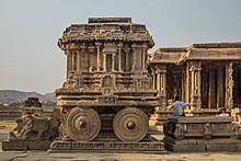
Between the colonnaded stone shop ruins is a broad road that allowed chariots to transport goods to and from the market, and hosted ceremonial functions and festive celebrations.
[83] Some of the books mention that its construction began during the time of Devaraya II and continued during the reign of Krishnadevaraya, Achuytaraya, and probably Sadasivaraya and it stopped due to the destruction of the city in 1565.
A similar monument dedicated to Narasimha, the man-lion avatar of Vishnu, is located east of Hampi; an inscription near it states that it was operating in 1379 CE.
[94] A colonnaded, open mandapa leads to the sanctum, which houses a monolithic image of Ganesha more than 4.5 metres (15 ft) high, which was carved in-situ from extant rock.
[96] The temple's outer walls portray the Hindu Mahanavami (Dasara) and the spring Holi festival procession and celebrations in parallel bands of artwork.
[99] This ruined temple complex is known for its thousands of carvings and inscriptions, its elaborate frescoes depicting Hindu theosophy and its sprawling courtyard laid with gardens.
In front of the temple is a dipa stambha (lighting pillar) under a Pipal tree, and inside is a sanctum dedicated to Rama, Sita, Lakshmana and Hanuman.
The third level reliefs show a battle procession, couples and scenes of common citizens celebrating Holi (Vasantotsava) by throwing water at each other.
[64][65] Hampi also had a dedicated public Bhojana shala (house of food) where numerous thali (dish) were carved in series in a rock on both sides of a water channel.
One example is found near an octagonal fountain in the south of the royal centre;[119] according to epigraphical sources, this Hampi bhojan shala was a utada kaluve or "canal connected with eating".
[124] The Lotus Mahal combines a symmetrical, square, Hindu mandala design with lobed arches, vaults, and domes of the Indo-Islamic style.
[124] Like almost all of the structures in Hampi's royal centre, this monument has no inscriptions nor epigraphs mentioning it and therefore dating it and establishing its function with evidence has been difficult.
[124][125] In the sacred centre near the southern banks of the Tungabhadra River and close to the Vitthala temple complex, are gateways and a monument now called the King's Balance.
[126][127][128] The Vijayanagara rulers built forts, fortified gateways and watchtowers after their dynasty was founded from the ruins of war and for security from repeated raids and invasion.
[139] In the memoirs of Niccolò de' Conti, an Italian merchant and traveller who visited Hampi about 1420, the city had an estimated circumference of 60 miles (97 km) and it enclosed agriculture and settlements in its fortifications.
He wrote his memoir as Chronica dos reis de Bisnaga, in which he stated Vijayanagara was "as large as Rome, and very beautiful to the sight ... the best provided city in the world".
He wrote, "the citie of Bezeneger (Hampi-Vijayanagara) is not altogether destroyed, yet the houses stand still, but emptie, and there is dwelling in them nothing, as is reported, but Tygres and other wild beasts".
He writes, "its evident moral is that civilization is a precarious thing, whose delicate complex of order and liberty, culture and peace may at any time be overthrown by war and ferocious violence.