Hampton, London
Refrigeration, air freight and cheaper overseas labour ultimately rendered the market gardens and nurseries uncompetitive and derelict, and after a lengthy planning process the Nurserylands estate was established in north Hampton in the 1980s.
The local geology comprises Kempton Park Gravel above London Clay, on which the Thames deposits fertile, well-drained alluvial soils, making it an attractive area for human habitation and settlement.
[4][5][6] There is evidence of small hunter-gatherer communities in the Thames Valley in the Palaeolithic period, who would have hunted migrating animal herds (reindeer and horse) depending on seasonal conditions.
[6][9] Evidence of Neolithic and Bronze Age settlement activity in the area is widespread, during a period when the level of the River Thames would have been significantly lower than at present.
[10] Before the Roman invasion of Britain, the Hampton area was occupied by the Catuvellauni, a Celtic tribe with its centre of government at Watamestede, near modern-day St Albans.
The Hampton settlement developed under the manorial system (where tenant serfs work the arable farm and grazing land of the manor on behalf of the absentee lord) as an agricultural domain primarily supporting neighbouring Kingston, which by the 9th century was a significant royal estate.
The assessed 1086 value was 9 pounds less than prior to the conquest, attributed to the devastation caused by Norman forces on their circuitous route around London as they sought its subjugation.
[23][24] After the Conquest the Manors of Hampton and Isleworth (comprising the hundred of Hounslow) were granted to Walter of Saint-Valéry, from whose home town in Flanders, Saint Valery-sur-Somme, William had sailed in 1066.
[26] In 1189 the estate passed to Thomas de St Valerie, who, as a baron in the "extraordinarily difficult" position of holding large possessions on both sides of the English Channel in the time of Magna Carta and the rebellion against King John, appears to have taken the precaution of severing the two holdings—transferring the Manor of Hampton to Henry de St Albans, a London merchant, and the Manor of Isleworth to his daughter Annora's husband, Robert III of Dreux—at some point before the 1217 Battle of Lincoln (in which he was implicated and ultimately exiled).
In 1500 the Lord Chamberlain Sir Giles Daubeney ordered that 300 acres of the demesne near Hampton be enclosed for hunting, taking out a lease for the entire manor in 1505.
[41][42] All the villages around Hampton Court are infected, and I found yesterday, I, the Duke of Verneuil, while having my walk along the main road, the body of a man who had just died of plague.
The curve of the railway line would come to define the suburb of Hampton distinct from the original village, but did not immediately lead to an increase in population (unlike neighbouring Teddington).
[58] Hampton developed into its current form of a residential suburb of London over the course of the late 19th and 20th centuries, as the families of professional workers settled within commuting distance of the city, and demand for local shops and services grew.
[64] Suburban development of the area bound north of the railway line took place mostly during the Interwar period:[u][65] the streetplan laid out generally following old lanes and field boundaries.
[71][72] The exchange switched from manual operation to Subscriber Trunk Dialling in the 1960s, and an additional building constructed on the other side of Old Farm Passage[x] ini 1982.
Just then an officer rushed out of the tent and shouted, "Don't fire at the goddamned thing – let it go over and hit some other poor sons of bitches – get in the ditch and take those boys with you."
As we dived into the ditch, the V1's engine cut out ...In 1944 V1 flying bombs and later V2 rockets either passed over or landed in or near Hampton (their distinctive noises recorded in residents' diaries)[ac].
The Hampton nurseries had begun to face competition in the 1960s from overseas and domestic produce sourced using refrigeration, air freight and cheaper labour, and by the 1970s had become uncompetitive and increasingly derelict.
During the 1970s several historic Thames Street properties backing onto the river became derelict, partly due to the planning blight associated with proposals to construct an elevated road along the riverside,[ag], and were successively demolished during the 1980s.
In 1904 shipbuilder John Isaac Thornycroft established the Hampton Launch Works, generating cabin cruisers and pleasure craft, including world water speed record holder Miss England III.
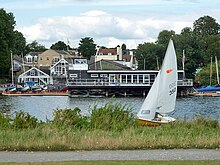
In the 19th century, barges carrying up to 200 tons of material, hauled by men or horses along tow paths, were a common sight along the Hampton/Molesey Reach and an integral part of the river economy.
Restler, and the site comprises filter beds and four massive engine pump houses constructed in Gault brick, with large arched windows and decorative balustrades.
Numerous alterations were made to the house during Garrick's residence by the neoclassical architect Robert Adam, including an imposing portico, the building of an orangery and the construction of a tunnel under the road to connect with his riverside lawn.
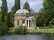
The architect designed an octagonal domed building modelled on the Pantheon in the Classical style with an Ionic portico, to be constructed in the villa's riverside garden.
[116] The building sports blue plaques for former residents, the singer John Beard and William Ewart MP, the Politician behind the Public Libraries Act 1850.
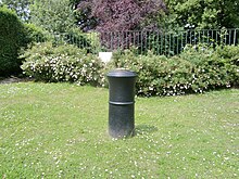
[53] In the park of St Albans Riverside beside the bridge leading to Tagg's Island is a sundial, "a globe with numbered longitude fins and tropic latitudes, resting on three balls, all upon a bell-shaped base" designed by David Harber.
[127] Hampton Heated Open Air Pool and Gym near Bushy Park was built in 1922 after plans approved in 1914 were delayed due to the outbreak of the First World War.
Eliot sought respite from the intrigues of London's literary circles (and his wife Vivien) by holing up at the Bell Inn in Hampton, writing to his editor John Hayward under the nom-de-plume 'White Cargo'.
[165] In keeping with its lack of high rise buildings, the district has no dual carriageways, its main routes the A308 and A312, have in their busiest sections an additional filter or bus lane.
A History of the County of Middlesex: Volume 3, Shepperton, Staines, Stanwell, Sunbury, Teddington, Heston and Isleworth, Twickenham, Cowley, Cranford, West Drayton, Greenford, Hanwell, Harefield and Harlington.


