Hand compass
[8] Hand compasses were soon widely employed in the practice of forestry, geology, archaeology, speleology, preliminary cartography and land surveying.
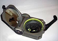
Traditionally, cruiser compasses featured a sighting notch, a mechanically-damped[9] or "dry" needle, adjustable declination and a large dial marked in individual degrees using counterclockwise calibration (reversed east and west positions).
[10] By the late 1960s many foresters had begun using more modern liquid-damped compass designs, including mirror-sight protractor models such as the Silva Type 15 Ranger or the Suunto MC-1 (later, the MC-2).
[14] By using a hand compass in combination with aerial photographs and maps a person can determine his/her location in the field, determine direction to landmarks or destinations, estimate distance, estimate area, and find points of interest (marked boundary lines, USGS marker, plot centers).
[15] While the hand compass continues to be widely employed in such work, it has been increasingly supplanted in recent years by use of the GPS, or Global Positioning System receiver.