Harbor Defenses of the Delaware
During World War II the defenses were relocated to Fort Miles on Cape Henlopen at the mouth of the Delaware Bay.
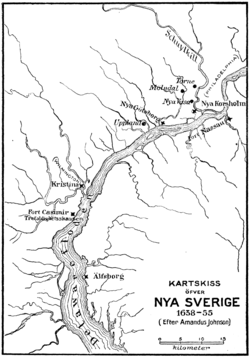
In 1638, Swedish, Finnish, and renegade Dutch settlers led by Peter Minuit established the colony of New Sweden at Fort Christina (present-day Wilmington, Delaware) and quickly spread out in the valley.
In 1648, the Dutch built Fort Beversreede on the west bank of the Delaware, south of the Schuylkill near the present-day Eastwick neighborhood, to reassert their dominion over the area.
In 1655, a Dutch military campaign led by New Netherland Director-General Peter Stuyvesant took control of the Swedish colony, ending its claim to independence.
The Swedish and Finnish settlers continued to have their own militia, religion, and courts, and to enjoy substantial autonomy under the Dutch.
The English conquered the New Netherland colony in 1664, though the situation did not change substantially until 1682 when the area was included in William Penn's charter for Pennsylvania, under which the city of Philadelphia was founded.
They fostered good relations with Lenape (Delaware) tribe, purchasing the colony's land from them, and had the only significant European settlements in the Americas without fortifications.
The Philadelphia Committee of Safety, headed by Benjamin Franklin, decided to protect the city by obstructing British access to the Delaware River.
Three forts were built to protect two lines of chevaux de frise obstacles in the river, designed by Robert Smith.
In early 1777 the British planned to cut New England off from the rest of the colonies by sending a force under John Burgoyne southward from Montreal through the Lake Champlain area and the Hudson Valley to Albany.
However, George Germain, a British civilian official managing the war in London, also gave approval for Howe to capture Philadelphia.
Word of it reached Commissioner Benjamin Franklin in Paris on December 4, and negotiations resulted in France declaring war on Britain in March 1778.
Eventually, the American victory in the Yorktown campaign on October 19, 1781 proved to be the key to independence; the British received word of it on November 25.
The new Whig government suspended offensive operations in the Thirteen Colonies and commenced lengthy peace negotiations, culminating in the Treaty of Paris that ended the war on September 3, 1783.
[35] Completion of the project was delayed years past the proposed date due to uneven settling, improper pile placement and the island's marshy nature.
[38] The fort was designed by Army chief engineer Joseph G. Totten, and construction was supervised by Major John Sanders.
[40] Many of the Confederate prisoners and Union guards who died at the fort are buried in the nearby Finn's Point National Cemetery in Pennsville, New Jersey.
Both were to house heavy guns and coast defense mortars, but were not completed or fully armed, as construction funding for forts was cut off in 1878.
[46] The Board of Fortifications was convened in 1885 under Secretary of War William Crowninshield Endicott to develop recommendations for a full replacement of existing coast defenses.
A parados (basically an artificial hill) and moat were placed behind the gun batteries to impede an assault from the landward side.
[50] Unusually, weapons were removed from CD Delaware prior to the US entry into World War I to arm higher-priority defenses.
At most coast defense commands, garrisons were drawn down to provide experienced gun crews on the Western Front, mostly using French- and British-made weapons.
[47][1] References indicate that the authorized strength of CD Delaware in World War I was 11 companies, including one from the New Jersey National Guard.
[55] In 1920 Fort Saulsbury was completed near Slaughter Beach and Milford, Delaware, with two batteries of a new type: 12-inch guns on long-range barbette carriages.
Fort Saulsbury was an example of new defenses being built seaward as gun ranges increased, and largely superseded the other heavy weapons in HD Delaware.
[58][59] Early in World War II numerous temporary buildings were again constructed at the forts to accommodate the rapid mobilization of men and equipment.
Two were used to arm Battery Reed, Fort Amezquita in the Harbor Defenses of San Juan, Puerto Rico; the third went to Watervliet Arsenal, New York.
This battery effectively superseded all other heavy weapons in HD Delaware, the third time new defenses were built seaward as gun ranges increased.
These included heavy earth-covered concrete bunkers for ammunition and fire control, with the guns protected by open-back shields.
[44] The increasingly remote threat of an enemy surface attack and an Army-wide shift from a regimental to a battalion-based system meant drawdowns in HD Delaware, starting in early 1944.