Harrisburg, Illinois
At the beginning of recorded American history, the Harrisburg area was inhabited by several Algonquian tribes, including the Shawnee and Piankashaw, who lived in the dense inland forests.
Prior to the War of 1812, most of the population of today's Saline County lived in cabins clustered around blockhouses to protect against Indian attack and dangerous wildlife such as cougars and bears.
There were no roads in the county and many residents from the areas of Carrier Mills and Stonefort became lost when traveling to the northern settlements of Raleigh, Galatia, and Eldorado.
The designated town plat was considered due to its aesthetic properties, a 60-foot (18 m) sandstone bluff overlooking the Saline River valley called "Crusoe's Island".
[9] The Cairo and Vincennes Railroad was completed in 1872 by Ambrose Burnside, and American Civil War, Union Army, brigadier general Green Berry Raum, who was living in Harrisburg at that time.
[10] Located on Commercial Street across the tracks from the train depot, The Southern Illinois Milling & Elevator Company was incorporated on July 29, 1891, by Philip H. Eisenmayer, with a capital stock of $50,000.
[4] After a series of corporate transactions brought the Cairo and Vincennes Railroad into the hands of the Cleveland, Cincinnati, Chicago & St. Louis Railway around 1890, with Illinois state representative Charles P Skaggs as mayor,[13] Harrisburg evolved into one of the leading coal-mining centers of the Midwest.
[5] Harrisburg was a strategic spot on the railroad route with a large hump yard, making it the focal point for the most productive coal field operations.
Large numbers of immigrants from England, Wales, and eastern Europe, looking for work, detrained at the Harrisburg Train Depot; crowding around quickly expanding mining villages directly outside the city, such as Muddy, Wasson, Harco and Ledford.
If the city combined the service communities bordering Harrisburg such as Ledford and Muddy, the population would have been even greater at 26,000, and Saline County as a whole reached nearly 40,000 people.
On June 17, 1936, Eleanor Roosevelt visited Harrisburg to observe work of the WPA and delivered a speech in the packed high school gymnasium.
[19] In 1950 Illinois Assistant State Attorney General George N. Leighton represented parents in a proceeding which desegregated the public schools of Harrisburg.
During the 1970s and 1980s, many of the city-square storefronts and mini-plazas became vacant and were slowly abandoned as large chain stores and strip malls on Commercial Street became the dominant venues for shopping and entertainment, hoping to bring an influx of travelers from the main highway.
[5] The Cairo and Vincennes Railroad/Cleveland, Cincinnati, Chicago and St. Louis Railway system tracks were taken up in the late 1980s and replaced by the Tunnel Hill State Trail in 1996.
In 2011, the Chief Deputy of the Saline County Sheriffs Department was sentenced to prison for sexually abusing a high school student who was working as an intern.
[44] The square in the center of town, as well as Dorrisville and Gaskins City, stand on top of a series of sandstone bluffs that were once islands rising above natural lowlands, 338 feet (103 m) above sea level, dredged by the middle fork of the Saline River.
[48] More than 270,000 acres (1,100 km2) of Shawnee National Forest lie to the south of Harrisburg, drawing visitors annually to the Saline County area and the gateway community.
[50] When the Shawnee Purchase Units were first established, temporary headquarters were set up in Room 303, First Trust and Savings Bank Building, Harrisburg, Illinois.
Employees who were here during the early days of the forest tell of the chaos and confusion caused by the small space under lease, the incoming shipments of equipment and supplies, and the constant inflow of new personnel.
[51] After the 5.5 Richter Scale magnitude 1968 Illinois earthquake, scientists realized that there was a previously unknown fault under Saline County, just south of Eldorado near Harrisburg.
[52] Seismographic mapping completed by geologists reveal that monoclines, anticlines, and synclines are present within the region; these signs suggest deformation during the Paleozoic era coincident to strike-slip faulting nearby.
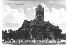
In the 19th century, the town had dirt streets with a large Greek Revival courthouse with Doric columns built by Swiss-born, Evansville, Indiana Architect J. K. Frick & Co in 1861.
Two buildings in Harrisburg are currently listed on the National Register of Historic Places, those being the City Hall and the Saline County Poor Farm.
[56] The square itself held an array of coal mining offices, privately owned business, grocery and department stores, pharmacies and bars.
[19] Over the years, the architecture that graced Harrisburg square has slowly turned to rotting older structures mixed in with a hodge-podge of newer updated buildings.
[23] Between Gallatin County and Harrisburg, about 25 miles (40 km) of Illinois Route 13 was covered by 8.0 to 14.0 feet (2.4 to 4.3 m) of water; motorboats navigated the entire distance to rescue marooned families.
The Pankey Branch pumping system, on the east side of town, was built to handle flooding from the Saline River only, and has serious complex watershed technical problems, causing continual water backup within the levee during large rain events.
[85] The storm damage in Harrisburg dominated national airwaves for several days, with both Anderson Cooper and Diane Sawyer doing special reports.
[86][87] Both The New York Times and Chicago Tribune published articles about the resilient history and nature of Harrisburg to rebound from the tornado and floods that have hit the city since its founding in 1889.
[91] It is the major daily newspaper serving Harrisburg, Saline County, and distributes to Paducah, Kentucky, Cape Girardeau, Missouri, and Mount Vernon, Illinois.