Hassan district
As per local legend Hassan name was abridged form of Simhasanapuri which is associated with Janamejaya king, it is believed he had lived here during his cursed period.
In the 17th and 18th centuries, Hassan became a land of contention between the Keladi Nayakas of Shimoga and the Mysore Kingdom.
During the 14th century, invasions by the Sultanate of Delhi weakened the Hoysala Kingdom, and the district became part of the Vijayanagara Empire.
In the 17th and 18th centuries, Hassan became a land of contention between the Keladi Nayakas of Shimoga and the Mysore Kingdom.
In 1648 the Mysore rulers built Channarayapatna fort by treaty with the sultans of Bijapur.
[7] The district remained part of the Mysore Kingdom at the conclusion of the Fourth Anglo-Mysore War in 1799.
[9] Reserve forests were established in the 19th century, and covered an area of 185 square miles in the district.
Lying between 12° 13´ and 13° 33´ North latitudes and 75° 33´ and 76°38´ East longitude, Hassan district has a total area of 6826.15 km2.
The general level of Hassan district slopes with the course of the Hemavati, from the peaks of the Western Ghats downwards to the southeast.
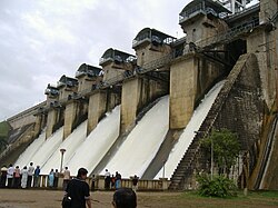
In 1981 the Hemavathi Dam was completed near Gorur, downstream from the confluence with the Yagachi, creating a reservoir of 8000 hectares.
Western portions of the district are drained by the headwaters of the Netravati River, which flows northwestward to empty into the Arabian Sea.
The basins of the Kaveri and Tungabhadra are separated by a range of low granitic hills extending through Belur, Hassan, and Arsikere taluks.
Hassan district is located on the leeward side of Western Ghats, thus receives less rainfall than coastal Karnataka.
[13] Main crops grown in the district are ragi, coconut,[14] potato, paddy, sugarcane, maize, coffee and black pepper.
According to the 2011 census Hassan district has a population of 1,776,421,[18] roughly equal to the nation of The Gambia[19] or the US state of Nebraska.