Hatfield Chase
It was a royal hunting ground until Charles I appointed the Dutch engineer Cornelius Vermuyden to drain it in 1626.
It was not wholly successful, but changed the whole nature of a wide swathe of land including the Isle of Axholme, and caused legal disputes for the rest of the century.
The civil engineer John Smeaton looked at the problem of wintertime flooding in the 1760s, and some remedial work was carried out.
The drains ran to the northeastern corner of the Chase and continued to sluices at Althorpe on the River Trent.
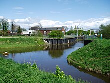
[3] The Chase is crossed by the River Torne, for which a new channel was cut by Vermuyden in 1628, as part of the drainage scheme implemented at that time.
Further north, the two peat bogs were separated by the completion in 1802 of the Stainforth and Keadby Canal, running in an east-west direction between the two.
[5] Hatfield Chase lay above the confluence of three rivers, the Don, the Torne, and the Idle, which meandered into the Trent near its entrance to the Humber.
A 2-mile (3.2 km) bank which ran along the south side of the river from Fishlake to Thorne included a navigable sluice, to allow boats to reach Sandtoft.
An 8-mile (13 km) drain was cut from where the Idle had been blocked to Dirtness, passing under the Torne at Tunnel Pits.
At Dirtness it was joined by another drain, bringing water from the west, and then ran for a further 5 miles (8 km) to another sluice at Althorpe.
[9] The drainage transformed the whole area, creating rich agricultural land where there had previously been swamps though it was still subject to periodic flooding.
The flooding of Fishlake and Sykehouse resulted from there being insufficient washlands to hold the flow of the Don while the sluice at Turnbridgedike was closed by high water levels in the Aire.
This still did not fully alleviate the problems of flooding, and so a new 5-mile (8 km) embanked channel was constructed from Newbridge to the River Ouse at Goole between 1632 and 1635.
[9] After various lawsuits and petitions, locals took action during the confusion of the Civil War and flooded Hatfield Chase by raising floodgates and damaging banks and sluices.
[9] The region was still affected by wintertime flooding in the 18th century, and the civil engineer John Smeaton was asked to make an assessment.
[9] The steam engine was sited at Little Hirst in 1848, but experience showed that it needed to be nearer to the drainage district, and so it was moved to Bull Hassocks in 1858.
The areas which were subject to taxation were extended, and the act listed 21 townships and parishes which would be required to pay for the drainage works.
The building contained two compound beam engines, driving a single scoop wheel which was 33.25 by 6 feet (10.13 by 1.83 m) and weighed 80 tons.
Despite this change, the management of the area continued much as before, with official records stating that the catchment board acted as the Corporation of the Level of Hatfield Chase, even though it no longer existed legally.
The order cited the powers of the 1813 and 1862 acts and transferred the property and responsibilities for drainage of the area from Severn Trent to the corporation.
At Dirtness, the single electric pump was supplemented by two more in 1951, rated at 105 brake horsepower (78 kW) and each capable of moving 110 tons per minute (161 Mld).
All of these watercourses converge on Pilfrey Junction, from where three parallel channels, called Three Rivers, flow to a pumping station at Keadby.
It was built in 1940, when six Crossley diesel engines, rated at 420 hp (310 kW) and driving 60-inch (150 cm) Gwynnes pumps were installed.