Hawaii (island)
He spent several weeks there, meeting and trading with locals and readying his ships for a planned trip to the Arctic.
However, his ships were damaged in a storm immediately after setting sail, and he was forced to return to Kealakekua after only a week at sea.
During this second anchoring, an altercation between the Europeans and the Hawaiians turned violent, resulting in the death of multiple people on both sides, including Cook himself.
The three chiefs, aided by Western ships and weapons, fought to a standstill for eight years until 1790, when Keōua defeated and killed Keawemaʻuhili.
[12]: 32–38 Kamehameha went on to conquer the rest of the Hawaiian islands, consolidating his control in 1810 with the peaceful surrender of Kaumualiʻi, king of Kauai.
[13] In 1822, missionary William Ellis arrived and was one of a party that completed a tour of the island, descriptions of which were later published in his journal.
Based on geochemical (including trace elements) and isotope differences in their eruptive products, Hawaiian volcanoes fall into two families.
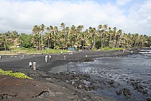
Lava flowing from Kīlauea destroyed several towns, including Kapoho in 1960 and again in 2018, and Kalapana and Kaimū in 1990.
In 1987 lava filled in "Queen's Bath", a large, L-shaped, freshwater pool in the Kalapana area.
[21] Another 875 acres were added between May and July 2018 by the 2018 lower Puna eruption, with "Fissure 8" located within Leilani Estates subdivision being a primary source of the lava.
According to the United States Geological Survey (USGS), the Great Crack is the result of crustal dilation from magmatic intrusions into the southwest rift zone of Kīlauea.
[28] While neither the earthquake of 1868 nor that of 1975 caused a measurable change in the Great Crack, lava welled out of its lower 6 miles (10 km) in 1823.
Between 1990 and 1993, Global Positioning System (GPS) measurements showed a southward displacement of about 4 inches (10 cm) per year.
[33] It triggered a landslide on Mauna Loa, 5 miles (8 km) north of Pāhala, killing 31 people.
The tsunami reportedly rolled over the tops of the coconut trees up to 60 feet (18 m) high, and it reached inland a distance of a quarter of a mile (400 meters) in some places.
[36] In March 2011, a 9.0 magnitude earthquake off the east coast of Japan again created a tsunami that caused minor damage in Hawaiʻi.
[37] In the Kona area this tsunami washed a house into Kealakekua Bay, destroyed a yacht club and tour boat offices in Keauhou Bay, caused extensive damage in Kailua-Kona, flooded the ground floor of the King Kamehameha Hotel,[38] and temporarily closed the Kona Village Resort.
[39] In early May 2018, hundreds of small earthquakes were detected on Kīlauea's East Rift Zone, leading officials to issue evacuation warnings.
On 3 May 2018, the volcano erupted in Puna after a 5.0 earthquake earlier in the day, causing evacuations of Leilani Estates and Lanipuna Gardens subdivisions.
Since the termination of volcanic activity in September 2018, vog has largely disappeared on the west side of the island.
[44] The gas plumes created a blanket of vog that the trade winds mostly deflect toward the Kona coast.
Major crops include macadamia nuts, papaya, flowers, tropical and temperate vegetables, aquaculture, and coffee beans.
The proposed addition of the Thirty Meter Telescope (TMT) generated protests that stalled the project and led to the transfer of management responsibility to a Governor-appointed body.
It provides resources and facilities for energy and ocean-related research, education, and commercial activities in an environmentally sound and culturally sensitive manner.
Business tenants on this coastal site include microalgae farms, aquaculture, solar technology and marine biotech.
The railway ran out of Hilo, northbound to Paʻauilo and southbound to Pāhoa, Glenwood (near Volcano), and Kamaili.