Interstate H-201
The 4.1-mile-long (6.6 km) loop route connects exits 13 and 19 on H-1, passing Fort Shafter, Tripler Army Medical Center, and the Red Hill Underground Fuel Storage Facility.
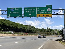
The freeway travels east through an interchange with H-1, which continues west toward Kapolei and south to Daniel K. Inouye International Airport, and H-3.
The freeway continues southeast, passing Moanalua Gardens and an industrial area, before it bisects Fort Shafter, a military installation in the Kalihi valley.
[10][11] The territorial government began preliminary construction of a four-lane divided highway to replace Moanalua Road in 1948, following the opening of the new Tripler Army Hospital.
[12][13] The project, which would reduce the number of curves on the road from 24 to 6, was also meant to connect with the Mauka Arterial (now part of H-1) and relieve congestion on the Kamehameha Highway near Pearl Harbor.
[17] The remaining section of the original Moanalua Road, bisecting Fort Shafter, was upgraded to a divided highway in the second phase and end at an interchange with the Lunalilo Freeway (also part of H-1).
[37] HDOT requested that the Moanalua Freeway be reclassified as an Interstate so that the interchange with H-1 at the eastern end could conform to federal highway standards.
Reasons given included the following: In July 2004, in conjunction with a major resurfacing of both sides of the freeway, it was decided to bring the signage in line with the official designation.