Heaphy Track
It is located within the Kahurangi National Park and classified as one of New Zealand's ten Great Walks by the Department of Conservation.
[2][3] The evidence from these investigations suggests that at least some of the area crossed by today's Heaphy Track had been explored and settled by Māori in pre-European times.
The first visit to the area by European persons whose names were recorded took place in 1846, when Charles Heaphy, Thomas Brunner and their Māori guide Kehu (Ngāti Apa ki te Rā Tō, Ngāti Tūmatakōkiri), supported by another guide Tau,[5] explored the coastal sector of the track.
They found a large scrub-covered area that was later named the Gouland Downs, but did not travel across it or mark out a route to the West Coast at that time.
[7] The first recorded crossing approximately along today's route was by a European gold miner named Aldrige in 1859.
[8] At the time, Mackay was returning from leading the Crown purchase from Māori of all the land on the West Coast within the Nelson province.
The Council engaged James Saxon a surveyor from Nelson, and he laid out a route suitable for horse carts from the Brown river to the Gouland Downs, with a grade of 1 in 16.
[13] In addition to the damage to bridges, the severe weather also caused slips and windfall on the track from James Mackay Hut down to the river valley.
[15] A helicopter shuttle service was established as an option to take walkers between Lewis Shelter and Heaphy Hut.
From the north, the road from Collingwood to Brown Hut is sealed as far as Bainham, then unsealed for the final 15 kilometres (9.3 mi).
[18] The road access was originally via three fords, but after ongoing concern about drivers taking risks in crossing the fords to get to the track, and some becoming stranded in swollen streams, DOC took the unusual step of providing funding to Tasman District Council for three bridges to be built; these were finished in 2014.
[20] Derry Kingston provided car transfer services until his retirement in 2018, driving a vehicle from one end to the other and then walking back.
There is a side-trip route up to the peak of Mount Perry, at 1,238 m (4,062 ft) elevation that in suitable conditions provides panoramic views over the Aorere Valley and Golden Bay towards the North Island, and inland over the Gouland Downs and the rest of the Kahurangi National Park.
Beneath the tussock in the Gouland Downs are sandstone and mudstone sedimentary rocks that were formed in the Lower Palaeozoic era around 400 to 500 million years ago.
The land was subsequently uplifted, and erosion removed most of the limestone, leaving isolated outcrops that now appear like tree-covered islands in the tussock landscape.
The remaining areas of the Gouland Downs have shallow and infertile soil where the only plants that thrive are tussocks and rushes.
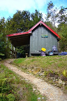
[28] The track from Gouland Downs Hut continues across the northern part of the Gouland Downs, crossing Shiner Brook, Big River and Weka Creek over swing bridges before descending into the headwaters of the Saxon River and reaching Saxon Hut.
The landscape of the coastline with its pounding surf and the coastal forest with groves of nīkau palms is described by some as the highlight of the track.
[4]: 191 Towards the end of this section of the track there is a climb from Scotts Beach to around 160 m (520 ft) over a saddle set back from Kōhaihai Bluff.
Lobbying activities to allow the return of mountain biking on the Heaphy track continued through until 2011, when a three-year trial began.
[37] In March 1972, a visitor from the United States, went missing on the climb up from Brown Hut in poor weather when she became separated from her tramping companion.
[38] In April 1973, a member of a party from the University of Canterbury Tramping Club was swept away while attempting to cross the flooded Cave Creek.
His abandoned campsite at Shakespeare Flat on the upper Aorere River was discovered by searchers but he was not found until 18 February – the final day of planned searches.
[43] Only a few weeks later, on 17 March 1980 three young trampers from Auckland died when they were swept off rocks at Crayfish Point, just 5 km (3.1 mi) from the end of the track at Kōhaihai.
There was another large search in April 1988 for a nurse from Auckland who had started on the track on her own from the Karamea end in mid March, and was last seen at Heaphy Hut.
[46] In October 1936, Bob Semple, the Minister for Public Works, questioned whether the proposed road was economically viable.
[48] The local West Coast and Collingwood population and councils largely supported the road, believing that a complete "tourist circuit" of the South Island would increase the access and popularity of their area.
[49] Other groups opposed to a road through the Heaphy Track included the Royal Forest and Bird Protection Society, Federated Mountain Clubs and the Nature Conservation Council.
Opposition groups criticised the plan for the destruction of up to 23 km (14 mi) of the Heaphy Track, including the unique sub-tropical coastal section.
[54] In response to further lobbying in 1996 by Buller Mayor Garry Howard, a commentator described the Karamea to Collingwood road as an “idea whose time has gone”.