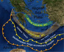
Hellenic subduction zone
The southernmost and shallowest part of the zone is obscured beneath the deformed thick sedimentary sequence that forms the Mediterranean Ridge accretionary complex.
The descending slab has been imaged using seismic tomography down to the top of the mantle transition zone at 410 km depth.
The degree to which the observed thrust faults within the ridge connect directly with the subduction interface remains unclear, due to poor seismic imaging caused by the presence of a thick layer of Messinian salt.
[6] The HSZ slab is divided into two main segments, the western and eastern, with the division between them running roughly north–south through central Crete.
Magmatism began in the early Pliocene, with typical arc-related andesite–dacite volcanism, stretching from the Saronic Gulf in the west to Santorini in the east.
In the mid to late Quaternary, the area of active volcanism spread into the eastern part of the SAVA, with a more varied chemistry, including tholeiitic and calk-alkaline basalts, large amounts of dacite with some rhyolite.
[10] This involves backstepping of the subduction zone southwards across each microcontinent, so maintaining a continuous slab, as suggested by the tomographic results.