Helvellyn
Since early 2018 the summit of Helvellyn including both Striding and Swirral Edges and the wider Glenridding Common have been managed by the John Muir Trust, a wild places conservation charity[1] under a three-year lease with the Lake District Park Authority.
[needs update] The volcanic rocks of which the mountain is made were formed in the caldera of an ancient volcano, many of them in violently explosive eruptions, about 450 million years ago during the Ordovician period.
Since the end of the last ice age, small populations of arctic-alpine plants have survived in favourable spots on rock ledges high in the eastern coves.
The top of Helvellyn is a broad plateau, trending roughly from north-west to south-east for about a kilometre between Lower Man and the start of Striding Edge.
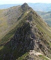
To the west the ground drops gently at first but then more steeply down to Thirlmere, while on the eastern side three deep glacial coves, each backed by high cliffs, are separated by two spectacular sharp ridges or arêtes.
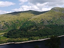
[2] Streams on the west side drain directly into Thirlmere, apart from Helvellyn Gill which flows into a parallel valley to the east of Great How and empties into St John's Beck.
A never-failing spring called Brownrigg Well exists 90 m (300 ft) below the summit of Helvellyn, about 500 m (550 yd) due west of the highest point, at the head of Whelpside Gill.
The north-west ridge continues from Lower Man over Browncove Crags, becoming almost insignificant when it reaches the shore of Thirlmere, yet still separating the valley of Helvellyn Gill from the reservoir, before finally rising again to the wooded height of Great How at its terminus.
The whole of Helvellyn, above the conifer plantations to the west and the intake walls surrounding the valleys of Glenridding and Grisedale to the east, is Open Access land.
Scramblers who continue on the top of the ridge are forced to descend an awkward short gully down from the final rock tower to rejoin the path.
Reaching the summit plateau involves a steep walk or scramble up about 80 m (260 ft) of rough rocky terrain, known as The Abyss by W. A. Poucher, author of a popular series of mountain guide books between 1940 and the late 1960s.
In winter conditions the climb from Striding Edge up to the summit plateau can involve crossing steep icy ground and a snow cornice, and can be the most dangerous part of the walk.
)[3] From Glenridding a similar long but safe and easy walk (11.5 km or 7+1⁄4 mi) follows Greenside Road, past the old lead mine and towards Keppel Cove.
Above the tarn the old pony track zigzags up the fellside, and takes a safe but unexciting route well away from crags on the side of the ridge, and avoiding all the intermediate tops.
[3] Shorter and quicker routes to the top of Helvellyn, though with less attractive scenery, begin from several points along the A591 road along the west side of the mountain.
A bridleway winds up the fellside, over Comb Crags and traverses the slopes of Nethermost Pike to arrive on the ridge at Swallow Scarth, the col just below Helvellyn.
Helvellyn can also be included in a circular walk from Patterdale: up Striding Edge, down to Grisedale Tarn and back over St Sunday Crag.
[23] The summit of Helvellyn takes the form of a broad plateau, sloping gently to the south-west, but dropping abruptly to the north-east into Red Tarn cove.
He quotes the account of an unnamed gentleman from Penrith who wanted to eat his dinner on Midsummer Day while sitting in a snowdrift on top of Helvellyn.
In August 1800, barely a month after moving there, he went to visit his friends William and Dorothy Wordsworth in Grasmere, taking a route over Helvellyn and arriving at ten in the evening.
[26] A few days later William Wordsworth with his brother John and their friend Mr Simpson made a trip up Helvellyn, setting out after breakfast and returning home at ten that evening.
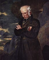
[28] A portrait of Wordsworth, deep in thought among the clouds on the summit of Helvellyn, was painted by Benjamin Robert Haydon in 1842, an example of romanticism in portraiture.
[8] William Ford, in his guidebook of 1839 recommended the Horse Head Inn at Wythburn as a good place to stay and where a guide could be hired "at a moderate charge"; he went on to describe the climb up Whelp Side and the view from the top.
At one time eagles (probably Aquila chrysaetos) soared over the mountain and bred on the steep cliffs above Red Tarn, but even in Wordsworth's day they had gone, having been persecuted to extinction.
Characteristic vegetation zones include a water-starwort (Callitriche) in shallower areas and the alga Nitella flexilis in deeper water and around the inlet.
The lowest part of the formation here is the densely welded lapilli tuff]] of the Thirlmere Member, in which the individual pieces of semi-molten lava were flattened under the weight of deposits above them.
The results are seen in moraines of unsorted boulder gravel in the valleys, the spectacular coves with steep headwalls, and the sharp arêtes formed where the rock was eroded on both sides between adjacent glaciers.
[40]: 233 Periglacial processes in seasonal freeze-thaw conditions, both present and past, have produced sorted stone stripes and solifluction lobes and sheets on the summit ridge of Helvellyn.
[5] Little can be seen of the levels now for the entrances were destroyed when the mine closed,[44] but several spoil heaps remain, one covering the gill, along with the old miners' path which zigzags up the hillside, a self-acting incline to lower ore to the dressing floor, and the old winding-drum house.
"[45] Hel is a Welsh word meaning to gather, drive or hunt, and helfa (historically spelt helva) has been used to describe a portion of mountain from which sheep are collected.


Click to enlarge