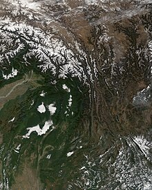
Hengduan Mountains
These ranges are characterized by significant vertical relief originating from the Indian subcontinent's collision with the Eurasian Plate, and further carved out by the major rivers draining the eastern Tibetan Plateau.
The Hengduan Mountains cover much of western present-day Sichuan province as well as the northwestern portions of Yunnan, the easternmost section of the Tibet Autonomous Region, and touching upon parts of southern Qinghai.
The dense, pristine forests, the relative isolation, and the fact that most of the area remained free from glaciation during the ice ages provides a very complex habitat with a high degree of biological diversity.
The ecoregions that coincide with the Hengduan Mountains are: Additionally, the lowest elevation portions of the Jinsha (Yangtze) River and Nu (Salween) River valleys in the southern Hengduan ranges are classified by the Chinese government as a tropical savanna environment.
Other species native to the mountains are the Chinese yew (Taxus chinensis) and various other rare plants, deer, and primates.