Henry W. Coe State Park
[2] Prior to its use as ranch land, the Diablo Range backcountry now covered by Henry W. Coe State Park was traversed by La Vereda del Monte, a trail between Point of Timber on the Sacramento River Delta and Cantua Creek in the San Joaquin Valley.
Joaquin Murrieta and his gang used the route to drive wild or stolen horses south from Contra Costa County, picking up more from stations along the way, passing into the area of the park from the San Antonio Valley via a trail that closely followed the route of County Line Road along the divide of the Diablo Range.
The park expanded considerably in the early 1980s with the purchase of adjacent properties to the east and south (the Gill-Mustang and Coit ranches, respectively), bringing the size to 67,000 acres (27,000 ha)).
[6] The person responsible for the fire came forward, pleaded no contest to a misdemeanor charge, and was ultimately ordered to pay $750,000 in restitution.
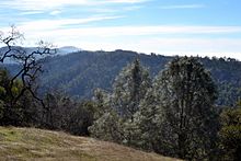
Located in the Diablo Range backcountry east of Morgan Hill, CA - between the San Antonio Valley (north) and Pacheco Pass (south), the park consists of a series of high ridges separated by steep walled canyons, with occasional level valley bottoms and distinct peaks.
The lowest point in the main body of the park is the place where the North Fork of Pacheco Creek flows out, at about 710 feet (220 m) elevation, also in the southeast corner.
After heavy rainfall, the creeks can become impassable, raging torrents, though usually they are not difficult to ford if one does not mind getting wet or (in winter and early spring) cold.
The park contains dozens of reservoirs created by the former ranch owners for watering cattle and for recreational fishing and hunting.
There are forested ridge-tops and slopes interspersed with chaparral and grasslands, with some creeks supporting distinct riparian vegetation.
Big-berry Manzanita (Arctostaphylos glauca) reach remarkable size within the park (over 20 feet (6 m) tall) and can grow as either small trees or large shrubs.
Other prominent shrubs and wildflowers include chamise (Adenostoma fasciculatum), toyon (Heteromeles arbutifolia), coyote brush (Baccharis pilularis), California sagebrush (Artemisia californica), eastwood manzanita (Arctostaphylos glandulosa), yerba santa (Eriodictyon californicum), buckbrush (Ceanothus cuneatus), California gooseberry (Ribes californicum), fuchsia-flowered gooseberry (Ribes speciosum), yellow mariposa lily (Calochortus luteus)[8] and mountain mahogany (Cercocarpus betuloides).
In reality, there is no evidence (stumps, historical accounts) that any significant logging took place, nor does the relatively wide extent of the stands and the great variety of age groups support a tree-planting theory.
When the climate warmed, the only places the trees could survive were up on the high cooler ridges and shady slopes where they grow today.
Chamise is undoubtedly the most abundant shrub in Coe Park, covering acres of hot, dry slopes and poor soils.
Large mammals making their home within Coe include blacktailed deer, tule elk, non-native wild pig, coyote, bobcat, and mountain lion (a.k.a.
Smaller mammals include raccoon, gray fox, striped skunk, Beechey ground squirrel, black-tailed jackrabbit, badger, and brush rabbit.
The Hunting Hollow access is best for casual walkers and bikers, as the 3-mile (4.8 km) valley trail is level, without any steep hills to traverse.
During the annual Coe Backcountry Weekend event in April, around 300 vehicles are permitted to travel up Kaiser Atena road as far as the Orestimba Corral which is 5 miles beyond the Dowdy Ranch visitors center.
A future entrance is planned to be located in San Antonio Valley in the northernmost part of the park, though it will likely be many years before funds are available to do this.
Many sources of water are found within the park, including seasonal springs and watercourses and old ponds built by the cattle ranchers.
These were often made with insufficient forethought and often suffer moderate to severe erosion problems, or may be overgrown and difficult to follow much of the year.
Backpackers also have the opportunity to fish while in the park as several of the lakes support large populations of largemouth bass and bluegill.
The park is considered mountain bike friendly from the Hunting Hollow entrance, since there are only a few miles of trails off limits to them (though this includes the whole of Orestimba Wilderness, but this is too far away for most bicyclists to reach on a day ride).
Motorized vehicles are prohibited in the backcountry; exceptions are law enforcement, maintenance staff, and a few dirt roads are designated rights-of-way for in-holders, neighboring property owners and their guests.
Spring is the most popular time to visit the park, with its moderate weather, green hillsides dotted with colorful wildflowers, and flowing creeks.
Summer is usually too hot and dry for some people to enjoy the area, though the nighttime weather is pleasant and the sky usually clear for star-gazing.
The most common danger faced by visitors is exhaustion from attempting to hike or ride too many steep trails in too little time, or with too little water or food.
The park's non-profit support group, the Pine Ridge Association, sponsors two popular annual events, a Mothers' Day Breakfast and the fall TarantulaFest.
The latter consists of a traditional outdoor barbecue with live music and a celebration of the hairy arachnids which inhabit the park, the gentle tarantulas commonly seen in the fall there when males are wandering about looking for the burrows of females in order to mate with them.