Herznach
In the early 14th Century, the Habsburgs had the right to judge and punish theft and other felonies in Herznach.
Between the Imperial Reform (1495) of Maximilian I until the fall of the Ancien Régime (1797) it belonged to the Austrian District of Rheinfelden.
The rights to Zwing und Bann (administration of the Commons as well as low justice) were probably in the hands of the village cooperative.
With the Act of Mediation in 1803, the Fricktal joined the Canton of Aargau and Herznach and Ueken became independent municipalities.
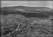
The two former population centers Unterherznach (walled church district) and Oberherznach (mill) grew together along the road by 1811.
[3] Starting in the Middle Ages and again during the Second World War there was intensive ore mining in the municipality.
At the beginning of the 21st Century Herznach was a farming community with a residential core and two industrial plants.
Of the rest of the land, 0.72 km2 (0.28 sq mi) or 11.5% is settled (buildings or roads), and 0.02 km2 (4.9 acres) or 0.3% is either rivers or lakes.
22.5% of the total land area is heavily forested and 2.1% is covered with orchards or small clusters of trees.
[4] The municipality is located in the Laufenburg district in the upper Fricktal (Frick river valley).
The blazon of the municipal coat of arms is Gules a Pitcher Vert lip dexter and handled Or.
The pitcher on the coat of arms is an attribute of Saint Verena to whom the chapel of Herznach is devoted.
[10] About 70.4% of the total households were owner occupied, or in other words did not pay rent (though they may have a mortgage or a rent-to-own agreement).

1782-1783

