High-altitude balloon
Modern balloons generally contain electronic equipment such as radio transmitters, cameras, or satellite navigation systems, such as GPS receivers.
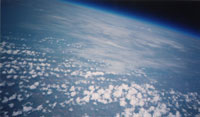
These balloons are launched into what is defined as "near space", defined as the area of Earth's atmosphere between the Armstrong limit (18–19 km (11–12 mi) above sea level), where pressure falls to the point that a human being cannot survive without a pressurised suit, and the Kármán line (100 km (62 mi) above sea level[2]), where astrodynamics must take over from aerodynamics in order to maintain flight.
Due to the low cost of GPS and communications equipment, high-altitude ballooning is a popular hobby, with organizations such as UKHAS assisting the development of payloads.
Common uses include meteorology, atmospheric and climate research, collection of imagery from near space, amateur radio applications, and submillimetre astronomy.
In many countries, the bureaucratic overhead required for high altitude balloon launches is minimal when the payload is below a certain weight threshold, typically on the order of a few kilograms.
Despite their smaller size, these HABs still often ascend to (and past) altitudes on the order of 30,000 m (98,000 ft), providing easy stratospheric access for scientific and educational purposes.
Often referred to as "The Poor Man's Space Program", ARHAB allows amateurs to design functioning models of spacecraft and launch them into a space-like environment.
[citation needed] In addition to the tracking equipment, other payload components may include sensors, data loggers, cameras, amateur television (ATV) transmitters or other scientific instruments.
[citation needed] A typical ARHAB flight uses a standard latex weather balloon, lasts around 2–3 hours, and reaches 25–35 km (16–22 mi) in altitude.
A zero-pressure flight by the Spirit of Knoxville Balloon Program in March 2008 lasted over 40 hours and landed off the coast of Ireland, over 5,400 km (3,400 mi) from its launch point.
All of the BEAR payloads carry a tracking system comprising a GPS receiver, an APRS encoder, and a radio transmitter module.
Other experimental payload modules include an Amateur Radio crossband repeater, and a digital camera, all of which is contained within an insulated foam box suspended below the balloon.
Besides conducting scientific activities, schools, influencers and other individuals have launched a wide variety of novelty payloads to the stratosphere with high-altitude balloons.
These have included teddy bears,[29] LEGO figurines,[30][31] hamburgers,[31] pizza,[32][33][34] Cornish pasties,[35] garlic bread,[36] bacon and cans of beer.
[31] Japanese electronics manufacturer Toshiba attempted to record an advertisement in near space with an armchair and cameras tethered to a high-altitude balloon.
Laser broadband would connect the GBS to the network, which could then provide a large area of coverage because of its wider line of sight over the curvature of the Earth and unimpeded Fresnel zone.