High Stile
The Ennerdale flanks are steep and rough with areas of crag, the lower slopes being planted with a ribbon of conifers.
North west of High Stile is Bleaberry Comb, backed by the wall of Chapel Crags.
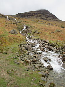
[3] Bleaberry Tarn is drained into Buttermere by Sourmilk Gill, reaching the lake mere yards from its outlet.
The lack of a retaining moraine means that this hollow has no tarn, Comb Beck running uninterrupted to the Lake.
These corries being scooped out of the northern face result in the connecting ridges between the three Buttermere Fells being fine and narrow.
The northern slopes display the underlying olistostrome of disrupted, sheared and folded mudstone, siltstone and sandstone of the Buttermere Formation.
It marks the course of a rock avalanche which fell from Grey Crag on the summit rim of High Stile, and was channeled along the foot of the glacier some 11,000 years ago.
The highest point on the main ridge is only three feet (0.9 m) lower and was regarded as the summit by Alfred Wainwright,[1] the maps available at the time not deciding the issue.
In an attempt to avoid confusion some guidebooks refer to the summit as Grey Crag and the top on the ridge as High Stile.
From Buttermere village the path to Bleaberry Tarn can be used, branching off to find a line around the eastern end of Chapel Crags.
High Stile above