Thai highway network
The Thai highway network follows the left-hand traffic rule of the road.
The network is the twin responsibility of the Department of Highways (DOH, Thai: กรมทางหลวง, Krom Thang Luang), and the Department of Rural Roads (DORR, กรมทางหลวงชนบท, Krom Thang Luang Chonnabot), under the oversight of the Transportation ministry of Thailand.
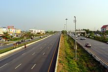
Dual carriageways have frequent u-turn lanes and intersections slowing down traffic.
A national highway (Thai: ทางหลวงแผ่นดิน) is a primary highway, part of the network connecting regions, provinces, districts, and other important destinations, for which the DOH carries out construction, expansion, upkeep and repairs.
[4] Four digits indicate an intra-province highway connecting a provincial capital to its districts, or between important sites.
[4] DOH signs for public highways (ทางหลวง, thang luang) are white squares with a black garuda (ครุฑ khrut) centered above the route number.
The rural road network measures some 35,000 kilometres (22,000 mi), about 82 percent of which is paved.
On edges facing traffic, DOH kilometer stones usually show distances remaining to the next two towns, (amphoe seats, or provincial capitals.)