Historical configuration of the province of Granada
The current configuration of the province of Granada is the result of a long process of territorial organization that reached its culmination in 1833, by means of the decree of provincialization promulgated by Javier de Burgos, Ministry of Development of the government of the regent Maria Christina of Bourbon.
The absolutist conception of the state encouraged the development of a series of projects, either of a liberalism or conservative nature, which would replace the old historical kingdoms of the Reconquest with the modern Spanish provinces.
The former Kingdom of Granada will be an important part of this process, given the imbalance of its superficial extension with respect to other provinces and its internal heterogeneity, which made its supervision and administration by the central state very difficult.
On the other hand, the towns of Puebla de Santa María (El Bosque), Setenil, Grazalema, Villaluenga del Rosario, Benaocaz, Ubrique and Alcalá del Valle, today in the province of Cádiz, and those of Sill plate and Bélmez de la Moraleda, which are currently integrated in the province of Jaén, were part of the Kingdom of Granada.
[6] This demarcation was only administrative and fiscal, since the kingdom of Granada, incorporated into the Crown of Castile, did not have any type of attribution over its limits or political capacity for autonomous action or decision, beyond municipal life and the vote in Cortes.
The territory was divided into zones or partitions for the collection of rents and extraordinary rights for the Crown, in some cases based on the existing ecclesiastical circumscriptions.
The numerous enterprises that Charles I and later Philip II undertook provoked a slight attempt at territorial organization capitalized in the 17 cities that were represented in the Cortes.
[9] In the early Modern Age, there was no single criterion for the determination of the regional entities within the Crown of Castile: Lucio Marineo Sículo[note 3] (1500), when distinguishing the different Spanish provinces, followed the Roman provincialization, while Pedro de Medina[10] (1548) made another classification, in which the Kingdom of Granada was differentiated from Andalusia.
The complex organization of the territory inherited from the Habsburg and the long medieval processes of reconquest and repopulation was archaic and irrational in many aspects, disproportionate and clearly insufficient for an absolute monarchy with increasing economic needs.
[13] Among the reforms undertaken was the realization of a statistical study that made it possible to quantify the country's resources and therefore facilitated their control and exploitation: the Catastro of Ensenada (1749), in which the 22 provinces of the Crown of Castile, including the Kingdom of Granada, were registered.
The project was conceived by the Count of Floridablanca, who in 1785 asked each of the intendants for a list of data on the territorial and civil organization and the jurisdictional division of their respective districts.
[6] The main shortcomings found were: the great contrasts in the extension of the provinces as well as their spatial discontinuity forming numerous enclaves and exclaves.
[23] A more profound restructuring process of the territory began in 1809, thanks to the political changes that arose in 1808 with the abdication of Charles IV and Ferdinand VII in favor of Joseph Bonaparte, turning Spain into a satellite state of the Napoleonic Empire.
[24]Llorente's project was approved without problems with the changes made by José María de Lanz y Zaldíbar, who completed the project, taking Llorente's departmental division as a model and, by virtue of the Decree of 17 April 1810 –signed in the Real Alcázar of Seville–, established a number of 38 prefectures,[25] this time giving priority in the nomenclature to the name of the capital and the subdivision into three sub-prefectures as a general rule.
Although the provincial boundaries were again very similar to those that existed at the end of the 18th century, the most significant change was the incorporation of the districts of Antequera and Archidona, whose borders followed the current boundary of the provinces of Malaga and Cordoba to Fuente de Piedra, excluding the towns of Teba and Campillos, Alameda, Peñarrubia, Sierra de Yeguas, Ardales, Almargen and Cañete la Real.
Despite the eccentricity of the capital with respect to the territory, it was not a problem due to its strategic location at the confluence of the roads between Baza, Granada and Almeria.
After this period, during the Liberal Triennium (1820–1823), the question of the territorial organization of the Spanish state did not take long to return to the political arena.
Once again, Felipe Bauzá from La Rioja was in charge of the technical work, on this occasion with the collaboration of José Agustín de Larramendi from Guipuzcoa.
Spain was divided into 52 provinces in the face of protests from cities whose rank in the traditional organization was higher, such as Barcelona, Santiago and Granada.
Two problems arose in the face of this proposal: the outright refusal of the deputies from Granada and the opposition from Almería, which wanted to opt for the capital.
The province of Granada from then on would be configured with boundaries very similar to those it has today: The definitive restoration of the absolutist monarchy of Ferdinand VII put an end once again to the administrative demarcation approved during the Trienio Liberal.
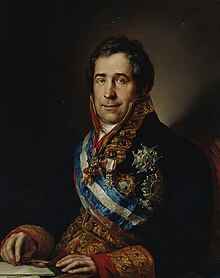
In 1833, Minister Javier de Burgos, by means of the Royal Decree of 30 November 1833, definitively culminated the process of provincial division.
[40] The provincial division was accompanied by the judicial demarcation, carried out by the Royal Decree of 21 April 1834, based on the studies directed by Calomarde.
Based on the Dictionary of Pascual Madoz, the province of Granada was comprised in 1843 by 204 municipalities, which at present have been reduced to 174 in a very complex process of segregation and integration that we try to summarize in the following tables.
These are the cases of Játar, Domingo Pérez de Granada, Dehesas Viejas, La Rábita, Valderrubio,[46] Zagra, Deifontes, Cuevas del Campo or Píñar.
Symptomatic was the case of the merger between Moreda and Laborcillas, giving rise to the term Morelábor, toponym formed by the conjunction of the beginning of both localities.
Once again, the mountainous areas are the most prone to this phenomenon, since in them –given the fragmented nature of the terrain– there is an abundance of municipalities of small size –both in extension and population– that are willing to merge with each other to have greater political and management capacity.
Very significant examples are the creation of Lecrín, Los Guájares, Valle del Zalabí, Alpujarra de la Sierra, among others.