History of Brittany
In the course of its protohistory which began around the middle of the third century BCE, a subsoil rich in tin allowed the development of an industry in bronze objects, which led to commercial routes for export to other regions of Europe.
As part of Armorica since the Gallo-Roman period, Brittany developed an important maritime trade network near the ports of Nantes, Vannes, and Alet, as well as salting factories along its coasts.
Since 939, Brittany was re-established as a Sovereign Duchy with somewhat definite borders, administered by Dukes of Breton houses from 939 to 1166, before falling into the sphere of influence of the Plantagenets and then the Capets.
The question of the proper place for the Breton language and regional traditions became the central element of a political movement which began to emerge in the same era.
[1] The oldest traces of habitat are located in Saint-Colomban, in Carnac, and take the form of settlements built in natural shelters (cliffs created by the erosion along the coasts).
[2] The oldest traces of fire use (in the region but also of occidental Europe) are found on the site of Menez Dregan with a date making them up to 400 000 years BC.
[2] The Upper Paleolithic is characterized by refined tools like blades and lamellae found on the site of Beg-ar-C'Hastel in Kerlouan, or at Plasenn-al-Lomm on the island of Bréhat.
[5] Human societies are more structured, with a degree of specialization of activities in a given community (as indicated by studies of the Téviec burial site)[6] and the beginning of an artistic expression.
Salterns are widespread in Northern Armorica, for example at Trégor, Ebihens and Enez Vihan near Pleumeur-Bodou (Côtes-d'Armor) and the island of Yoc'h near Landuvez (Finistère) of late La Tène date.
At the salterns at Landrellec and Enez Vihan at Pleumeur-Bodou the remains of rectangular ovens have been excavated that are 2.5–3 m long and about 1 m wide, constructed of stones and clay.
The Romans called the district Armorica (a Latinisation of a Celtic word meaning "coastal region"), part of the Gallia Lugdunensis province.
The Notitia Dignitatum (circa 400 AD) mentions a number of local units manning the Tractus armoricanus et nervicanus, for example Mauritanian troops in the territory of the Veneti and Osismii.
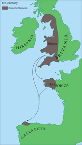
Other British and Welsh authors (Nennius and Gildas) mention a second wave of South-Western Britons from Dumnonia, settling in Armorica in the following century to escape the invading Anglo-Saxons and Irish.
Conan Meriadoc, the mythic founder of the house of Rohan, is mentioned by medieval Welsh sources as having led the settlement of Brittany by mercenaries serving Maximus.
The Welsh text The Dream of Maxen, which contains semi-factual information about the usurpation of Maximus, states that they married native women after cutting out their tongues to preserve the purity of their language.
In the Early Middle Ages, Brittany was divided into three kingdoms – Domnonia (Devnent), Cornouaille (Kernev), and Bro Waroc'h (Broërec) – which eventually were incorporated into the larger Breton state.
The rulers of Domnonia such as Conomor sought to expand their territory (including holdings in British Devon and Cornwall), claiming overlordship over all Bretons, though there was constant tension between local lords.
In 845 the Breton army under Nominoe defeated the forces of Charles the Bald, King of West Francia (France), at the Battle of Ballon, in the eastern part of Brittany near Redon and the Frankish border.
Nominoe gained control over the major towns of Rennes and Nantes, which had previously formed part of the Frankish border zone known as the "Breton March".
Control over Rennes, Nantes and the Pays de Retz was secured when the Frankish army was defeated once again in 851 at the Battle of Jengland by the Bretons under Erispoe; consequently Charles the Bald recognised the independence of Brittany and determined the borders that defined the historic duchy and later province.
Under Erispoe's successor Salomon, Hastein's Vikings and the Bretons united as one in 866 to defeat a Frankish army at the Battle of Brissarthe, near modern-day Le Mans.
The parties were the half-brother of the last duke, John of Montfort (supported by the English), and his niece, Joanna of Penthièvre, who was married to Charles of Blois, nephew of the king of France.
John's wife, duchess Joanna de France besieged the rebels and set free her husband, who confiscated the Penthièvre's goods.
The territory of Brittany was divided in 1789 into five départements, partially on the basis of earlier divisions called présidiaux which in turn had issued from medieval bailliages.
Charles Armand Tuffin, marquis de la Rouërie was a significant figure in this plot but ultimately ended up in hiding after a secret agent divulged his participation to Georges Danton.
[19][22] In light of these mounting foreign threats, the Committee of Public Safety sent Republican troops known as ‘Representatives on a Mission’ to local regions—such as Brittany—to ensure the preservation of national unity within France.
[23] The order of the National Convention on 14 August 1793 declared that these Representatives "take every measure of interior and exterior defense which they may consider necessary" contributed to the nation-wide violence experienced during the Terror.
[24] Jean-Baptiste Carrier, one prominent Representative on a Mission, who had been sent to Brittany, dutifully reported to the Committee of Public Safety that he would "arrest those declared guilty of the counter-revolutionary disorders committed by this company".
[25] In the 19th-century Brittany acquired a reputation for timeless autarky, as Romantics developed an image of the province as a bastion of peasant traditionalism, religious festivals, and wild landscapes.
After 1944, Breton nationalism was widely discredited thanks to the collaboration of a number of prominent nationalists (such as Roparz Hemon) with the Nazis, who occupied Brittany along with most of the rest of the French state during the Second World War.