History of Cardiff
Until the Roman conquest of Britain, Cardiff was part of the territory of an Iron Age Celtic British tribe called the Silures, which included the areas that would become known as Brecknockshire, Monmouthshire and Glamorgan.
Mesolithic hunter-gatherers from Central Europe began to migrate northwards from the end of the last ice age (between 12,000 and 10,000 years before present(BP)).
Doggerland was submerged by the North Sea and, by 8000 BP, the British Peninsula had become the island of Great Britain.
[1][2][3] John Davies has theorised that the story of Cantre'r Gwaelod's drowning and tales in the Mabinogion, of the waters between Wales and Ireland being narrower and shallower, may be distant folk memories of this time.
[1] As Great Britain became heavily wooded, movement between different areas was restricted, and travel between what was to become known as Wales and continental Europe became easier by sea, rather than by land.
[4] These Neolithic colonists integrated with the indigenous people, gradually changing their lifestyles from a nomadic life of hunting and gathering, to become farmers, some of whom settled in the area that would become Glamorgan.
[5] They cleared the forests to establish pasture and to cultivate the land, developed new technologies such as ceramics and textile production, and they brought a tradition of long barrow construction that began in continental Europe during the 7th millennium BC.
[11] There is a group of five tumuli at the top of Mynydd y Garth—near the City and County of Cardiff's northern boundary—thought to be Bronze Age, one of which supports a trig.
[18] Archaeological evidence shows that a settlement had been established by the Silures in central Cardiff in the 50s AD, probably during the period following their victory over the Roman army.
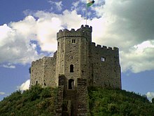
[19] Excavations from inside Cardiff Castle walls suggest Roman legions arrived in the area as early as AD 54–68 during the reign of the Emperor Nero.
[20] The Silures were not finally conquered until c. AD 75, when Sextus Julius Frontinus' long campaign against them began to succeed, and they gained control of the whole of Wales.
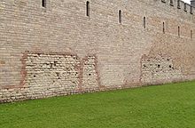
[19] Another fort was built on the site around 250, with stone walls 10 ft (3.0 m) thick along with an earth bank, to help defend against attacks from Hibernia.
In 1316 Llywelyn Bren, Ifor Bach's great-grandson, also attacked Cardiff Castle as part of a revolt.
The battle, between a Royalist rebellion and a New Model Army detachment, was a decisive victory for the Parliamentarians and allowed Oliver Cromwell to conquer Wales.
[21] It is the last major battle to occur in Wales, with a total death toll of about 200 (mostly Royalist) soldiers killed.
[33] In the 1790s, a race track, printing press, bank and coffee room all opened, and Cardiff gained a stagecoach service to London.
Iolo Morganwg called it "an obscure and inconsiderable place", and the 1801 census found the population to be only 1,870, making Cardiff only the twenty-fifth largest town in Wales, well behind Merthyr Tydfil and Swansea.
[33] The town grew rapidly from the 1830s onwards, when the Marquess of Bute built a dock which eventually linked to the Taff Vale Railway.
Cardiff became the main port for exports of coal from the Cynon, Rhondda, and Rhymney valleys, and grew at a rate of nearly 80% per decade between 1840 and 1870.
Barry docks had the advantage of being accessible in all tides, and David Davies claimed that his venture would cause "grass to grow in the streets of Cardiff".
[34] The city also strengthened its industrial base with the decision of Guest, Keen and Nettlefolds, owners of the Dowlais Ironworks in Merthyr, to build a new steelworks close to the docks at East Moors in 1890.
[38][39] Bomb damage during the Cardiff Blitz in World War II included the devastation of Llandaff Cathedral, and in the immediate postwar years the city's link with the Bute family came to an end.
The East Moors Steelworks closed in 1978 and Cardiff lost population during the 1980s,[41] consistent with a wider pattern of counter urbanisation in Britain.
[47] However, the Assembly eventually located at Crickhowell House in Cardiff Bay in 1999; in 2005, a new debating chamber on an adjacent site, designed by Richard Rogers, was opened.