History of Minneapolis
The origin and growth of the city was spurred by the proximity of Fort Snelling, the first major United States military presence in the area, and by its location on Saint Anthony Falls, which provided power for sawmills and flour mills.
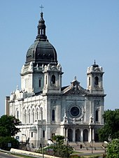
As the city grew, the culture developed through its churches, arts institutions, the University of Minnesota, and a famous park system designed by Horace Cleveland and Theodore Wirth.
The city's land was acquired by the United States in a series of treaties and purchases negotiated with the Mdewakanton band of the Dakota and separately with European nations.
[10] It was called "Lowell" for its water features,[10] "Addiesville"[11] or "Adasville"[10] for a daughter of settler Charles Hoag, "Winona" by those who wished to preserve indigenous language,[10] and "Brooklyn".
The sawmills also supported related industries such as mills that planed and smoothed the lumber; factories that built sashes, doors, and windows; and manufacturers of shingles and wooden buckets.
The fix was a concrete dike (wall) built by the Corps of Engineers just upstream from the falls all the way across the river from just under the limestone cap down as much as 40 feet (12 m).
[6] The St. Anthony Express newspaper predicted in 1855 that, "The time is not distant when Minnesota, with the superiority of her soil and seasons for wheat culture, and her unparalleled water power for manufacturing flour, will export largely of this article.
[19] In 1882, the first central station (supplying multiple users) hydroelectric power plant in the United States was built at the falls on Upton Island.
His objective was to build a hydroelectric plant that would sell energy to Twin City Rapid Transit, which was then using steam power to generate electricity.
It helped farmers by ensuring that they got the best prices possible for their wheat, oats, and corn, since the usual supply and demand curves were skewed by similar harvest times across the region.
The farmers of the southern plains developed a variety of hardy red winter wheat suitable for bread flour, and the Kansas City area gained prominence in milling.
Congressional approval for the Upper Minneapolis Harbor Development Project came in 1937 but it wasn't until 1950 through 1963, that the United States Army Corps of Engineers constructed two sets of locks at the lower dam and at the falls.
State law in 1953 and the federal Fair Housing Act of 1968 prohibited discrimination, however restrictions against minorities were still found in many Minneapolis deeds as of 2017.
[56] Corruption spread to the MPD as an Irishman named Edward G. "Big Ed" Morgan operated gambling dens with bootleggers under police protection.
[63][64] This growth also allowed Minneapolis to annex land from neighboring villages and townships which subsequently pushed the incorporation of today's inner ring suburbs.
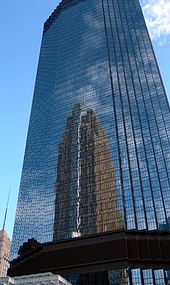
The construction of the First National – Soo Line Building in 1915, with a height of 252 feet (77 m), caused concerns among the real estate industry, so the 125-foot (twelve story) limit was reimposed at the request of the Minneapolis Civic and Commerce Association.
[8][page needed] The Gateway district, centered around the intersection of Hennepin and Nicollet Avenues just west of the Mississippi River, was the major casualty of urban renewal.
When General Mills announced in 1955 that they were moving their corporate headquarters to Golden Valley, city planners decided to implement a large-scale Gateway district plan that included demolishing a large number of buildings.
Minnesota State Highway 55, running southeast from downtown to the Fort Snelling area and the Minneapolis–Saint Paul International Airport, was slated to become a freeway, but the upgrade was canceled due to neighborhood opposition.
Riverside Plaza, formerly Cedar Square West, was completed in 1973 as a six tower mixed-income self-contained urban village that originally was much larger and contains the tallest buildings outside Downtown.
The plain modern and brutalist concrete styles of that period however were contrasted in the late 1990s to 2000s that brought in more prominent residential towers to the skyline with varying colors and architecture themes.
The Carlyle residence one block south of the Mississippi River is 41 stories built in art deco style and is the most recent addition to the skyline.
This line, part of the Metro system, starts in downtown Minneapolis and progresses southeastward along Minnesota State Highway 55 (also known as Hiawatha Avenue), passes Minnehaha Park on the west side, and serves the Minneapolis–Saint Paul International Airport before it terminates at the Mall of America in Bloomington.
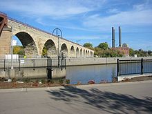
The Stone Arch Bridge was opened to pedestrian traffic in 1994, creating a link in the trail system and providing extensive views of Saint Anthony Falls.
As a result of discriminatory policies and racism throughout the city's history, racial disparities were described as the most significant issue facing Minneapolis in the first decades of the 21st century.
[74] In the 2010s, several deaths of black men in Minneapolis and the metropolitan region by police officers brought issues of structural racism to the city's forefront.
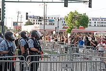
[75] In May 2020, following the murder of George Floyd, a black man, while under custody of Minneapolis police officers, protests exploded throughout the Minneapolis-St. Paul metropolitan area.
Some commentators blamed what they called a history of structural racism, lack of police accountability, state aggression against protest movements, and untenable social conditions in Minneapolis as contributing factors to the events that unfolded soon after Floyd's murder.
Estimates of property damage were upwards of $500 million, making the unrest in the Minneapolis-St. Paul area the second most destructive in United States history, after the 1992 Los Angeles riots.
Floyd's murder and the resulting unrest in Minneapolis inspired a global protest movement about structural racism and police brutality.