History of Pulicat
[3] In the 1st century, the anonymous mariner who wrote Periplus of the Erythraean Sea listed Podouke (Pulicat) as one of the three ports on the east coast of India.
[3] In the 7th century, during the Pallava period, Pulicat was named Mamalla Pattinam indicating it was an important coastal city worthy enough to carry the coronation title of a King.
[1] In the 13th century, A.H. 668 (1269 CE),[11] Arabic Suni-Shafi Khadems from Medina migrated to the shores of this lake after they were banished from Mecca for refusing to pay tributes to a new Caliph.
[12] From 1225 to 1275, Arab ships transporting tin from Malaya to Die, Oman or Dhufar regularly stopped at Pulicat.
[18] In 1422, at the beginning of the reign of Deva Raya II this port city was renamed Anandarayan Pattinam after the new governor Anandaraya.
[19] In the 15th and early 16th century, Pulicat rose to importance due to stabilization of the Vijayanagar empire and firm links, including a road, to the great imperial capital of Vijayanagara.
The Coromandal coast was a major producer of textiles and yarns for export to Melaka and Burma, and Anandarayan Pattinam was the port from which they were shipped.
[23] During this period, in Pulicat there was also a great industry for cutting and polishing precious stones as diamonds, sapphires and rubies procured from the Deccan, Ceylon and Pegu (Burma).
[26] After the 1556, Battle of Talikota resulted in a decline of the Vijayanagar Empire, Ibrahim Quli Qutub Shah Wali, the third ruler of the Kingdom of Golkonda took control of Palaverkadu.
[27] In 1586, Oboyoma, the favorite queen of Venkatapati Deva Raya, the Vijayanagaar emperor, now operating from the new capital at Chandragiri, was bequeathed Pulicat to rule.
After the death of Venkatapati Deva Raya in 1614 and a succession struggle, his son Ramadeva became king in 1617 and named his father in-law Ethiraja as master of Pulicat.
[28] In 1616, the Madurai Nayak ruler Muttu Virappa paid a tribute of 600,000 Pagodas to Venkatapati Deva Raya at Chandragiri.
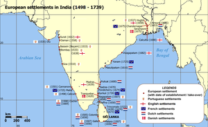
[16] Queen Eraivi, a wife of King Venkata II, ruled Prelaya Kaveri and during her reign in 1608 the Dutch East India Company (Verenigde Oostindische Compagnie or (VOC), was given permission to build a fort and do trading.
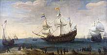
[7] They built a fort named Geldria at Pulicat as a defense from local kings and the Portuguese, from where they soon monopolized the lucrative textiles trade with the East Indies and other countries in the region.
In 1611, Venkatatapati turned against the Portuguese and the Jesuits were ordered to leave Chandragiri and the Dutch were permitted to build a fort at Pulicat.
In 1614, subsequent to the death of Venkatapati and taking advantage of a predicament in naming his successor, the Portuguese attacked the Dutch at Pulicat.
The trading involved spices including nutmeg, cloves, cinnamon, pepper, and tea, silk and Chinese porcelain.
Its output was so substantial that for several decades it was able to keep many of the major Dutch trading centers in the East Indies and homeward-bound fleets well supplied.
In the larger towns of Pulicat and Santhome alone the death toll was put at 15,000 and only one third of the textile weavers, painters and washers survived.
For most of the 16th and 17th centuries Europeans on the Coromandal coast were extensively involved in the trading, brokering and shipment of slaves from India to Ceylon and the West Indies.
[56] Normally 150 – 400 slaves were shipped each year from central Coromandel ports, including Pulicat, Madras, Nagapatnam and Devanampatnam.
[59] Slave labour was a defining element of the high production levels and luxury standards of Dutch colonial settlements throughout the Indian Ocean.
Slaves empowered the elite groups, and formed 25% – 66% of the total population of the major settlements, including Pulicat.
[64] The traders, descendants of the Khadems from Medina who were previously socially undifferentiated from the boat builders, became a distinct group of "nobility" called Labbay.


Circa. 1656 [ 36 ]