History of Yarmouth, Maine
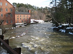
Around three hundred sea-going vessels were built in the numerous shipyards in Yarmouth harbor from around 1790 to 1890, while almost sixty mills were founded over 250 years along the town's section of the Royal River, making use of its four waterfalls for power.
During the years prior to the arrival of the Europeans, many Native American cultures existed in the area,[3] largely because of the natural features of the coastal land.
Rivers provided several resources, including food, fertile soil, power for the mills and the navigability between the inland areas and the ocean.
[4] In 1643, Englishman George Felt, who had emigrated to Charlestown, Massachusetts Bay Colony, eighteen years earlier, purchased 300 acres of land at Broad Cove from John Phillips (1607–c.
)[5] Englishman William Royall (c. 1595–1676),[6] a cooper, emigrated to Salem, Massachusetts Bay Colony, in July 1629, aboard the Lyon's Whelp.
Soon after, however, conflicts forged by King Philip's War (1675–1678) caused them to abandon their homes and move south.
[5] Some settlers returned to their dwellings in 1679, and within twelve months the region became incorporated as North Yarmouth, the eighth town of the Province of Maine.
[5] In 1684, an English military officer named Walter Gendall claimed to own all of Felt's two thousand acres in Casco Bay.
[9] The unrest kept the area deserted for many years, but by 1715 settlers revisited their homes, by which point they found their fields and the sites of their habitations covered by a young growth of trees.
[5] In 1722, a "Committee for the Resettlement of North Yarmouth" was formed in Boston, Province of Massachusetts Bay.
It surveyed land divisions made with 103 original proprietors, each with a home lot of ten acres.
[5] In August 1746, a party of thirty-two Indians secreted themselves near the Lower Falls for the apparent purpose of surprising Weare's garrison, in the process killing 35-year-old Philip Greely, whose barking dog blew their cover.
A few months later, Captain William McLellan, of Falmouth, was in Quebec in charge of a group of prisoners for exchange.
[3] The town's Main Street gradually became divided into the Upper Village (also known as the Corner) and Lower Falls, the split roughly located around the present-day U.S. Route 1 overpass (Brickyard Hollow, as it was known).
[5] The Yarmouth Village Improvement Society has added wooden plaques to over 100 notable buildings in town.
These include:[13][14] Another notable building is Camp Hammond (1889–90), at 275 Main Street, whose construction method is significant in that the building consists of a single exterior wall of heavy planks over timbers, with no hidden spaces or hollow walls.
Frederick Law Olmsted, who is responsible for the layout of New York's Central Park, designed the landscape for the exterior.
The split occurred due to bickering between the inland, farming-based contingent and the coastal maritime-oriented community.
Tanneries were built near brooks; potteries and brickyards put to use the natural clay in the area; and mills flourished along the Royal River, providing services such as iron-forging and fulling cloth.
[19] In 1887, a fire started in the dry grass south of Grand Trunk Station by a spark from a passing train.
Two hundred acres were burned, and the fire was only stopped because it reached the waters of Broad Cove.
A strong southerly breeze carried the sparks directly across the most thickly settled part of town, causing small fires in various places so that over twenty buildings were burning concurrently.
Early in the morning he would leave Princes Point, pick up the mail at Lower Falls, and then deliver letters to the northern edge of town, including Sligo and Mountfort Roads.
Each day, as he passed his farm on Princes Point Road, he would change horses and eat lunch with his wife, Harriet.
[17] In 1923, town historian William Hutchinson Rowe announced that a history of Yarmouth was in the works.
[19] A Grippe epidemic struck the town in January 1944, with two thousand residents placed into quarantine.