History of air traffic control in the United Kingdom
On 15 July 1919, the world's first commercial flight occurred, when Henry Shaw (1892-1977) piloted a de Havilland DH.9 for Aircraft Transport and Travel from Hendon to Le Bourget airfield in Paris.
From 1928, radio signals from Croydon, Pulham St Mary in Norfolk and Lymm in Kent triangulated the position of aircraft; a similar system was set up by Germany in 1940, known as the Battle of the Beams.
On 19 November 1933, the first form of ATC began in the London Zone, with a controlled zone, but no radar On the evening of 25 February 1935 at Stowe Nine Churches (Upper Stowe) in Northamptonshire, the so-called Daventry experiment took place with Robert Watson-Watt to prove that radar detection of aircraft was possible.
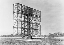
The first four radar stations were at Dover in July 1937, Canewdon in August 1937, followed by Great Bromley, and Dunkirk, Kent, with 358-feet masts, fabricated by J. L. Eve Construction.
[4] Ground-controlled interception (GCI) was first developed in the UK during the early part of WWII, at RAF Sopley in Hampshire, close to Bournemouth.
Development of the system began in October 1940, and the first ground-controlled interception took place on 1 January 1941 with the Bristol Beaufighter at RAF Middle Wallop, and the call sign Starlight.
Birmingham had been heavily bombed that night by 439 German aircraft, guided by KG 100; the Ju 88 pilot Unteroffizier Franz Sondermeier bailed out.
Although the rate of Luftwaffe combat losses, detected by AI radar, markedly increased throughout the first half of 1941, only three German bombers destroyed over Britain in February 1941,[7] around 50 in April and 102 in May.
As part of the Telecommunications Flying Unit, on 16 January 1945 at RAF Defford in Worcestershire, Boeing 247 DZ203 made the first automatic approach and landing.
After the war BEA planned to navigate its aircraft with the GEE system,[8] across Scotland and Northern Ireland.
The discipline of holding patterns was established at Stansted, and at Bournemouth, and conducted flights to calibrate VOR-DME transmitters.
Until better electronics had been installed, ground-control approaches at airports, in bad weather, were the scenes of a series of terrible accidents in the 1950s.
From the 1980s, ILS was trialled at main airports by the microwave landing system (MLS) as it was thought to be better for bad weather.
[26] MLS was fitted to runway 28R (called 27R from July 1987, due to movement of the Earth's magnetic field), at Heathrow from November 1986, but was not intended to be implemented across the country until around 1996.
[33] The London Area Control Centre at West Drayton moved to Swanwick, Hampshire at 2.30am on Sunday 27 January 2002, when 29-year-old controller Sarah Harris guided an Airtours International Flight AIH 550 from Gran Canaria Airport at Las Palmas safely into Birmingham Airport.
[34] Swanwick was intended to replace two sites at West Drayton and Manchester (at Manchester Airport), but the West Drayton centre remained open to oversee London and South East England, and was planned to close in 2007; it closed on 23 November 2007 when around 500 staff moved to Swanwick.
In the early 1960s, both military and civil radar operators were trained at a joint school at RAF Sopley.
[36] Around sixty countries would send ATC trainees to the College of Air Traffic Control (CATC) in Dorset, including Eastern Europe.
[41] In October 1978, Plessey received a £9m contract to build the radar and flight data processing system for the Austrian FIR.
[44] By the early 1960s, the USA required US-registered aircraft, flying above 25,000 ft, to have a transponder for secondary surveillance radar.
[46] Air France and BOAC ordered the Cossor SSR.1251 transponder system for their Boeing 707 aircraft.
[50] In April 1965 Russia (through Aviaexport) bought fifty SSR.1600 ATC Airborne Transponders for its Aeroflot fleet, and for manufacturers such as Tupolev, for £80,000.
From 1983, this system was internationally called Mode S (S=selective) to avoid FRUIT (False Returns Unsynchronised with Interrogator Transmissions).
27 Doppler VOR (VHF omnidirectional range) beacons, costing £3.5m, were built in 1982 by Racial Avionics (former Decca Radar) of New Malden.
[56] In the early 1990s most low-level (up to 100 feet) primary radars for airports and RAF airfields were updated to be the Plessey Watchman, which had around a 50 mile range.
The RAF had chosen the Watchman radar system for its airfields in the UK, and overseas, in June 1983.
On Thursday 9 June 1960, Britain, France, Belgium, Italy, Luxembourg, West Germany and Holland decided to coordinate air traffic control as jet aircraft were much quicker, to prevent collisions.
In 1981, the first computer data link between LATCC at West Drayton and Eurocontrol was established, followed by Brest Airport and Reims in 1986 and Paris in 1987; advanced boundary information (ABI) began in late 1990.
[102] Eurocontrol, established on 1 March 1964, had been initially set up for eventually becoming a Europe-wide full air traffic control system, but individual countries could not together form agreements for this to fully happen; this meant that by the late 1980s Eurocontrol oversaw only flights above 25,000 feet over the Netherlands, Belgium and part of West Germany.