History of neighbourhoods in Toronto
Sparsely populated in 1815, New Town grew rapidly during the 1820s and 1830s, and a rivalry formed between the two neighbourhoods, especially for the location of the Parliament Buildings.
Most of the rest of the region that today makes up the city was rural farmland dotted with small villages.
Some towns such as Norway have disappeared leaving only a few traces, but many others, such as Malvern and Wexford have become well known neighbourhoods in the Toronto suburbs.
The central Union Station was the meeting point of a number of lines, and this contributed to the growth of industry throughout the area between Queen Street and the lakeshore.
East and west of downtown, the major stations were established at Parkdale and Riverside South, which both became centres of activity.
Parts of town that had once been home to small rural communities were transformed by the railway into major industrial areas.
To the northwest of the city, the small towns of Carleton and Davenport were subsumed into The Junction and it became the site of many large factories and warehouses.
The working class Irish who laboured in many of the factories were concentrated in the eastern part of the city, and these neighbourhoods were named Cabbagetown and Corktown after them.
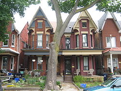
Middle and upper class residents left the core and moved into new areas further out, creating a number of new neighbourhoods.
The streetcar allowed residents living outside the central business district to travel to work with ease.
New areas, again mostly middle and upper class, grew up along the streetcar lines creating new neighbourhoods like Riverdale, The Beaches, Birch Cliff, North Toronto, and Parkdale.
Working class streetcar suburbs developed in New Toronto, Mimico and Long Branch in what is now Etobicoke.
[6] All of these neighbourhoods are still commonly used today, with the exception of Willowvale, which is now known as Christie Pits, the name of the park it surrounds having been changed the same way.
Scarborough, North York, and Etobicoke were transformed from largely rural farmland into vast stretches of housing.
The Financial District was growing northwards and The Ward and many of the oldest parts of Chinatown were demolished to make way for new projects, such as Toronto City Hall.
The government also demolished many other areas labelled as "slums", replacing them with modern housing projects that were hypothesized to lead to much better lives for the inhabitants.
In the suburbs, municipal governments also created new high rise neighbourhoods such as Flemingdon Park and Crescent Town.
[9] Residents and real estate soon found that giving neighbourhoods distinct names and identities made them more attractive.
To the west and east other residential and cultural zones have appeared in areas such as Liberty Village and the Distillery District.
With the disappearance of open spaces in the city of Toronto and the revitalization of the downtown there has been considerable condominium construction creating residential communities in areas that were once almost wholly commercial, such as the Financial District and Yorkville.