History of the Galveston Bay Area
Prior to European settlement the area around Galveston Bay was settled by the Karankawa and Atakapan tribes, who lived throughout the Gulf coast region.
In the early 19th century the pirate Jean Lafitte created a small, short-lived empire around the bay ruled from his base on Galveston Island before his being ousted by the United States Navy.
Commerce grew between Galveston, Harrisburg and Houston in the later 19th century, and created additional economic opportunities as railroads were built through the Bay Area to connect these and other commercial centers.
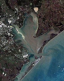
The present geography of the Gulf Coast was formed during an ice age approximately 30,000 years ago when dramatic lowering of the sea level occurred.
[1] As the ice later melted, it formed a flow through the Trinity and San Jacinto rivers and carved wide valleys in the soft sediments, resulting in the creation of the modern system of bays and lakes approximately 4,500 years ago.
[17] Encroachment by Spanish as well as U.S. settlers continued such that by the end of the century native populations had declined dramatically due to disease and territorial pressures from the Europeans.
Lafitte, at the time serving as a privateer for the Spanish Empire, transformed Galveston Island and the bay into a pirate kingdom he called Campeche.
Various failed attempts, such as the Long Expedition, were made by groups from the U.S. to take control of parts of Texas, resulting in some temporary settlements near the bay including Perry's Point near modern Anahuac.
[32][33] The company gradually brought in many colonists from the United States and Europe, although conflict with Mexican officials over colonization laws initially made these efforts difficult.
[36] Conflicts between Bradburn and the settlers in the region over land rights, slavery laws, and customs duties led to the Anahuac Disturbances, a prelude to the larger Texas rebellion.
[19] Inland from the bay, the towns of Harrisburg and Houston were both founded on the Buffalo Bayou by entrepreneurs from New York and competed as commercial centers, but neither was as significant as Galveston.
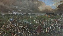
[47][48] During the American Civil War, in which Texas seceded from the United States, the area served a limited role in the conflict though no major battles were fought on the mainland shoreline.
New fortifications, like Fort Chambers near Anahuac, were constructed to ward off a mainland invasion by Union forces and to protect supply routes to and from Galveston.
[41][50] Some former slaves were able to take advantage of ranching's economic influence as some successful African American communities were established, including the "Settlement" in what is now League City.
[51] The success of the various enterprises in the area and the growth of Galveston as one of the prime commercial centers in the South and Southwest helped promote the construction of the Gulf, Colorado and Santa Fe Railway, and the La Porte, Houston and Northern Railroad over the course of the 19th century.
With amenities including bathhouses, boating piers, and a Victorial hotel with a dance pavilion, Sylvan Beach quickly became the most popular tourist destination in the Houston area.
Following the devastating 1900 hurricane, donations by the newly created Red Cross, including millions of strawberry plants to Gulf Coast farmers, helped revive area communities.
[52] This and the subsequent establishment of a major strawberry farm in the area by Texaco founder Joseph S. Cullinan made Pasadena an important fruit producer for many years afterward.
Mexicans, fleeing the Mexican Revolution in 1910, added significantly to the population of what is now Baytown; Sicilian immigrants added greatly to the community of Dickinson; and Japanese rice farmers settled in Webster, Pasadena, and League City[22][68][69][70] (in fact the rice industry on the U.S. Gulf Coast was born in Webster; see Seito Saibara).
[72] Wealthy Houstonians created waterfront retreats in Morgan's Point and a boardwalk amusement park at Sylvan Beach, La Porte (together known at the time as the Texas "Gold Coast"), as well as summer homes at Seabrook and other communities.
[73][55] The onset of Prohibition made Galveston Bay an important entry point for smuggling illegal liquor, which supplied most of Texas and much of the Midwest.
[76] Much of the area around Clear Lake was developed as recreational properties for the wealthy, including a large ranch estate owned by Houston businessman James West.
[43] During the World Wars, factories around the bay were pressed into service mass-producing a variety of products including aviation fuel, synthetic rubber, and ships.
[81] Drilling for oil and underground water, as well as large wakes from increasing shipping in the bay, led to land subsidence and erosion along the shoreline, especially in the Baytown-Pasadena area.
[82] Today approximately 100 acres (0.40 km2) of the historic San Jacinto battleground are submerged, most of Sylvan Beach is gone, and the once prominent Brownwood neighborhood of Baytown has had to be abandoned.
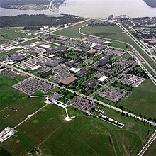
[72] The Clear Lake City community was created by the Friendswood Development Company, a venture of Humble Oil and Dell E. Webb Corporation, to support residential growth near the new NASA facility.
Industrial operations were expanded including the opening of the U.S. Steel plant in Baytown in 1970, and the Barbours Cut shipping terminal at Morgan's Point in 1977.
[90] Still, when the Texas economy declined in the later 1980s, the economic diversity of the area and substantial annual federal investments related to JSC helped the region fare better than most of Greater Houston.
[50] Conservation efforts in the mid to late 20th century by area industries and municipalities helped to dramatically improve water quality in the bay.
[98] Discussions of a proposal to build an Ike Dike that would protect the Bay Area, particularly the nationally critical Houston Ship Channel, were begun in 2009.