Rove Formation
After the Rove Formation sediments were deposited, the Penokean orogeny added more land mass by accretion that occurred from the south.
As a result of erosion of sandstone and the erosion-resistant sills and dikes, the topography in Minnesota has repeated parallel hills and valleys.
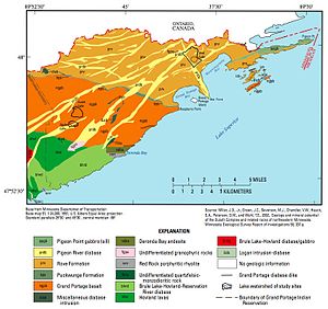
In Minnesota it occurs along the U.S.-Ontario border from Gunflint Lake to Pigeon Point (both in northeastern Cook County) and northward into Canada.
Many lakes in this 5 to 8 km (3 to 5 mi) wide band along the Canada–US border are in the elongated east–west valleys; included are Caribou, Clearwater, Crocodile, Daniels, Duncan, Dunn, Hungry Jack, Iron, Loon, Moose, Pine, Portage and South.
The Superior province is the largest preserved fragment of Archean crust,[7] and the Canadian shield is the nucleus of the North American craton.
[11] Greywacke is a sedimentary rock composed of a mixture of poorly sorted grains of sand, silt and clay particles.
Argillite is a fine-grained sedimentary rock composed primarily of clay particles; they are essentially lithified muds and oozes.
[13] The Resident Geologist Program, Geology of the Thunder Bay South District, reports an age of 1800 million years old.
[18] Evidence indicates a 16 km (10 mi) diameter meteorite collided with Earth[18] in the current-day vicinity of Sudbury, Ontario, Canada, about 1,850 million years ago.
The impact fundamentally affected concentrations of dissolved oxygen in the sea; the accumulation of marine sediments (known as banded-iron formations) were almost instantaneously shut down.
[19] Banded-iron formations are massive deposits rich in iron oxides; they accumulated at several periods in the Earth's geologic past.
Most of the impact layer in the Rove area consists of beccia, a mixture of rock fragments which ripped loose from the sea floor during the earthquakes.
[20] Geologists Mark Jirsa and Paul Weiblen from the University of Minnesota[20] took advantage of the burnt-over landscape resulting from the intense, hot Ham Lake fire to explore the newly exposed geology along the Gunflint Trail.
Jirsa picked up some rocks which turned out to be ash and debris from the 1,100 km (680 mi) distant impact site; this is the farthest distance that Sudbury detrita has been found.
The 2,000 km (1,200 mi) bow-shaped rift extended from northeastern Kansas, through the southeastern corner of Nebraska, diagonally northeast through Iowa, through Minnesota along the current Minnesota-Wisconsin border, arced through the present-day Lake Superior basin and angled southeasterly through Michigan.
In the Rove region the magma didn't reach the surface; it intruded into fractures in the formation and slowly cooled to become diabase (rather than basalt).
The solidified lava flows have sagged, tilted and faulted; this created a basin up to 5,000 m (16,000 ft) deep along the rift zone.
The Puckwunge Formation has buff to grey sandstone[22] which comes from sediments deposited during the early stages of the Midcontinent rift; zircon dating shows a time period of 1200 to 1100 million years ago.
[24] The Puckwunge exposure begins at Raspberry Point within the Grand Portage National Monument on Lake Superior, Cook County, Minnesota, and extends for about 40 km (25 mi) inland to the northwest.
[25]: 27 When continental glaciers moved over the Rove Formation area, the ice was a hundreds of meters thick and its surface sloped gently southward from the Patrician center to the north.
[12]: 22 The mesa at Russell Point (about 16 km (10 mi) south of Thunder Bay) is a Logan sill of diabase over the softer Rove Formation metasediments.
[12]: 79 It is one of the many flat-topped, steep-sided mesas along Lake Superior's northwestern shore south of Thunder Bay that are collectively known as the Nor'Wester Mountains.
[27] The diabase-capped ridges between the valleys slope gently to the south (4° to 15° from the horizontal);[25]: 24 the northern faces are precipitous; they rise 60 to 140 m (200 to 460 ft) above deep, cold lakes, creating an asymmetrical cross-section profile.
[26] The valleys contain glacially quarried bedrock lakes; they are also asymmetrical in cross section because of the same structural elements which control the ridge shapes.
[25]: 26 Ver Steeg reconstructed a preglacial drainage pattern that shows major streams flowing east in the slate belts.
[28] The relatively rich soils, particularly in the Royal River drainage area, along with steep, moist, north-facing cliffs provide the habitat for these rare plants.
[31]: 15 Virtually all of the known sensitive plant species in this landscape association occur on the north side of the cliffs or in the Royal River drainage.
[31]: 15 They are the Maidenhair spleenwort (Asplenium trichomanes L.),[32] in Minnesota six small populations of 20 to 40 plants have been found in the Rove area;[33]: 57 Ross's (or Short) sedge (Carex rossii), only three populations are known to exist in the Rove area;[34] Large-leaved sandwort (Moehringia macrophylla or Arenaria macrophylla), evidence indicates that this is a very rare species with limited distribution and restrictive environmental needs;[35] Sticky locoweed (Oxytropis borealis var.
[33]: 121 Minnesota's Department of Natural Resources lists these vascular plants as being threatened:[38] Rocky Mountain woodsia (Physematium scopulinum ssp.
[40] Minnesota's Department of Natural Resources lists the Nodding saxifrage (Saxifraga cernua) as endangered,[38] one source refers it to being "very rare"[33]: 161 and that Cook County has Minnesota's single colony with about a dozen plants – the entire population occupies less than a 1 m2 (1 sq yd) – so it is vulnerable to singular events which would alter its habitat.