History of the San Fernando Valley
Only when the waters encountered the rocky roots of the Santa Monica Mountains were they pushed to the surface where they fed a series of tule marshes, sloughs, and the sluggish stream that is now the Los Angeles River.
[2] By the time the Spanish conquest of Mexico reached Alta California in 1769, successive groups of indigenous peoples, or Native Americans, had inhabited the area for at least 7,000 years.
In the north-central Valley was an apparently permanent village called Pasakngna (Fernandeño: Paséknga, of unclear etymology), in the lower foothills of the mountains near natural springs and a tule marsh.
[8][9][10] In the Simi Hills the Burro Flats Painted Cave pictographs are located on Rocketdyne's Santa Susana Field Laboratory property, inaccessible but well protected.
Accompanying him were two Franciscan Padres, Junípero Serra and Juan Crespí, who recorded the expedition and identified locations for a proposed network of missions, along which the royal highway (El Camino Real) was eventually built.
After camping at and naming the location that would become the Pueblo de Los Angeles, the expedition proceeded westward before turning north through the Sepulveda Pass over the Santa Monica Mountains on the feast day of Saint Catherine of Bologna.
Father Crespí had identified a location along the Los Angeles River that would be perfect for a settlement, possibly a mission, but in 1781, King Charles III of Spain ordered that a pueblo be built on the site, which would be the second town in Alta California after San José de Guadalupe, founded in 1777.
By royal edict, all of the waters of the river and its tributaries were reserved for the Pueblo de Los Angeles, a condition which would have a profound impact on development of the Valley.
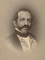
Francisco Reyes, alcalde or mayor of Los Angeles from 1793 to 1795, had set up a grazing operation which he called Rancho Encino located in what is now Mission Hills near the village of Pasakngna.
[20] The nearby Battle of Providencia of February 20, 1845, was another face-off between Californios and an unpopular Mexican governor, Manuel Micheltorena, who proposed to return the mission lands to the control of the church.
The only reported fatalities in the day-long cannon battle along the river were two horses and a mule, but Governor Micheltorena was captured and summarily shipped back to Mexico.
A square of land at the west end of the Valley near the historic Chumash village Hu'wam was granted to three of the mission Indians under the name Rancho El Escorpión.
In Southern California, the Mexicans, for a time, resisted American troops, but when defeat became inevitable, Pío Pico fled to Mexico.
The Butterfield Overland Mail stagecoach route between St. Louis, Missouri and San Francisco, California via Fort Yuma and Los Angeles made its first run in the fall of 1858.
The precipitous portion of the route down from the summit on the San Fernando Valley side was called the Devil's Slide; horses were usually blindfolded and chains were used to augment brakes on the steep descent.
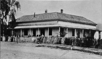
[32] By 1859, with the cattle market in collapse and besieged by mounting debts, De la Osa converted his house at Rancho Encino into a roadside inn and began to charge patrons for his legendary Californio hospitality.
When De Celis died in 1869, Pío Pico, desperately in need of cash, sold his half-share to a group of investors assembled as the San Fernando Farm Homestead Association.
The leading investor was Isaac Lankershim, a Northern California stockman and grain farmer, who was impressed by the Valley's wild oats and proposed to raise sheep on the property.
Van Nuys, however, thought the property could profitably grow wheat using the dryland farming technique developed on the Great Plains, and leased land from the Association to test his theories.
[37][38] A 56,000-acre (227 km2) parcel of De Celis's property north of the great furrow was purchased in 1874 by state senator Charles Maclay of Santa Clara and his partner, George K. Porter of San Francisco.
[39] The town plan included land for a station for Leland Stanford's Southern Pacific Railroad from Los Angeles, which became the depot for the north Valley farmers to ship their wheat crops south to the port at Wilmington.
[40] When the rival Santa Fe Railroad reached Los Angeles in 1885, fare wars between the two transportation giants brought ever more settlers to Southern California, and pressure rose to subdivide the great ranches of the Valley.
On April 1, 1888, they offered ready-made small farms for sale, already planted with deep-rooted deciduous fruit and nut trees—mostly peaches, pears, and walnuts—that could survive the rainless summers of the Valley by relying on the high water table along the Pacoima River (now the central or main branch of the Tujunga Wash) rather than surface irrigation.
The next year the Southern Pacific opened a branch line slanting northwest across the Valley to Chatsworth Park, which made one freight stop a day at Toluca, though the depot bore the new name of Lankershim.
[49] In October 1903, George K. Porter sold an option to purchase his last 16,200 acres (66 km2) of land in the north Valley to a syndicate led by Leslie C. Brand of Glendale.
In 1904, Brand's syndicate incorporated as the San Fernando Mission Land Company, whose major shareholders included Los Angeles businessmen Henry E. Huntington, E.H. Harriman, Edwin T. Earl, Joseph F. Sartori, and Harrison Gray Otis.
[50] One day after the city water commission, on which Moses Sherman sat, approved a proposal to build an aqueduct from the Owens Valley, the Company quietly exercised its option to purchase Porter's land.
In the "biggest land transaction ever recorded in Los Angeles County",[53] a syndicate led by Harry Chandler, business manager of the Los Angeles Times, with Hobart Johnstone Whitley, Isaac Van Nuys, and James Boon Lankershim acquired "Tract 1000", the remaining 47,500 acres (192 km2) of the southern half of the former Mission lands—everything west of the Lankershim town limits and south of the old furrow excepting the Rancho Encino.
[56] In 1912, Carl Laemmle broke ground on a permanent movie-making facility on the Providencia (Oak Crest Ranch) in the hills east of the mouth of the Cahuenga Pass that would become the first location of Universal City.
Small remote portions of the north and west Valley were annexed piecemeal even later: most of Rancho El Escorpión in 1958 and the remainder of Ben Porter's ranch as late as 1965.