History of the territorial organization of Spain
After the Arab conquest, the part of the peninsula controlled by the Moors was called, for centuries, Al Ándalus or alternatively Spania, although the process of Reconquest ended up eliminating these names.
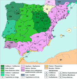
Later, some historians have tried to create families of tribes that share the same cultural characteristics, particularly distinguishing between Iberians in the Levant and south of the peninsula, Celts in the plateau and Vascones and Cantabri in the north.
Later, as Muslim power declined, the coras became independent, creating small states with their own king, the so-called Taifa kingdoms.
The territory of the kingdom of Castile was distributed among the 18 cities with the right to vote in Cortes and in turn subdivided into partidos, which in the census of 1591-1594 are not called that way, receiving in some cases also the name of province.
Twenty were the intendancies then created: those of La Coruña, León, Valladolid, Burgos, Pamplona, Zaragoza, Barcelona, Salamanca, Ávila, Guadalajara, Toledo, Madrid, Ciudad Real, Valencia, Mérida, Seville, Córdoba, Granada, Palma and Santa Cruz de Tenerife.
Tomás González Hernández, headmaster of the Cathedral Church of Plasencia, reorganizes the Royal Archive of Simancas, after the despoilment suffered after the Napoleonic invasion.
The archivist completes the so-called Book of the Millions with data from other regions: Catalonia, Basque Country, Navarre, Valencia and Aragon.
Under the reign of Carlos III, on March 22, 1785, the Count of Floridablanca promoted the creation of a Prontuario or nomenclator of the towns of Spain and maps were drawn up to facilitate the control of the kingdom:At the end of the Ancient Regime the local jurisdictions offered a picture even more obsolete and anachronistic than that of the old provinces; distributed in royal, abadengas and secular lordship jurisdictions, they were the result of historical circumstances accumulated over the centuries and represented the antithesis of rationality and administrative efficiency.
The liberal State needed a new territorial organization that would allow it to govern the country in a uniform manner, collect taxes and create a single market with equal laws for all.
This division was part of a project to reorganise the territory promoted by Miguel Cayetano Soler, general superintendent of finance, mainly with the intention of simplifying the tax system and rationalising the collection of taxes, so that the new reform gave a greater role to the delegates of the intendant —the subdelegates of revenue— and to the district boards.
In 1810, the Josephine government tried to order the territory by dividing it into 38 prefectures, in the style of those established in France, and 111 sub-prefectures, according to the project of the engineer and mathematician José María Lanz.
Thirty-eight peninsular prefectures were created, plus the Balearic and Canary Islands: Although the War of Independence prevented the adoption of all these reforms, in 1812 a decree allowed Catalonia to be annexed to France until 1814 as a new region divided into four departments: In 1811, the Cortes of Cadiz abolished the jurisdictional lordships, thus eliminating the division between seigneurialism and royalty, which, despite the restoration of absolutism by Ferdinand VII in 1814, would not come into force again.
The idea was that this division would cover the whole country, without exception, and would be the single framework for administrative, governmental, judicial and economic activities, according to criteria of legal equality, unity and efficiency.
This reform carried out by Javier de Burgos in 1833 basically adopted the 1822 project, and has been maintained with some changes —partition of the Canary Islands, inclusion of Castilian comarcas to Valencian provinces— up to the present day.
It divided the Spanish territory into 49 provinces on the basis of a rational criterion, with a relatively homogeneous size and eliminating most of the exclaves and enclaves typical of the Ancient Regime.
The main difference was that the Canary Islands had not been divided into two provinces to date, with Santa Cruz de Tenerife as their capital.
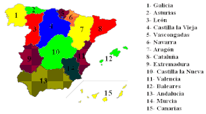
The first article of the draft reads as follows:The States of Andalusia Alta, Andalusia Baja, Aragon, Asturias, Balearic Islands, Canary Islands, Castilla la Nueva, Castilla la Vieja, Catalonia, Cuba, Extremadura, Galicia, Murcia, Navarre, Puerto Rico, Valencia, Regiones Vascongadas compose the Spanish Nation.
In 1964, the provinces of Rio Muni and Fernando Poo were organized in the Autonomous Regime of Equatorial Guinea, in force until its independence in 1968.
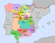
Each autonomous region is divided into several provinces —except the uniprovincial ones— which are the same, except for minor modifications, as those of Javier de Burgos' division.