Hofheim, Hesse
Hofheim is located in the Rhine Main Area, one of the fastest-growing regions in Germany in terms of population and also in regard to economic productivity.
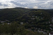
The highest point of Hofheim is the mountain Judenkopf in the Lorsbach district, with a height of 410 metres.
onwards, settlement areas on the banks of the Schwarzbach, on both sides of today's Schmelzweg and on the Kapellenberg have been identified.
[8] Hofheim belonged to Count Philipp VI the Elder of Falkenstein, when Emperor Charles IV on 21.
[12] But already in 1559 Elector and Archbishop Daniel Brendel von Homburg had redeemed an old pledge and thus regained Eppstein and Hofheim.
Under the reign of Wolfgang von Dalberg, Archbishop and Elector of Mainz, and his successor Johann Adam von Bicken, the witch trials in the Electorate of Mainz reached their peak in the period from 1588 to 1602 in both the Höchst and Hofheim districts.
On November 3, 2010, the town council of Hofheim am Taunus decided to rehabilitate the citizens convicted of witchcraft.
Until the beginning of 1603, Protestantism was still the predominant religion among the inhabitants despite the town's affiliation with the Catholic Electorate of Mainz.
[13] During the Thirty Years' War, Spanish, Bavarian, Swedish and French troops occupied, plundered and devastated the town and its present-day districts.
The following year Hofheim was still free of the plague and on July 3, 1666, Pastor Gleidener led the inhabitants in a procession to the "Rabberg" (today's Kapellenberg) to take a vow: If the town was spared from the plague, a chapel should be built on this spot in honor of the Blessed Virgin Mary.
Has next to the city wall; two small castles; surrounded by good moats, one of which is completely burned; but the other stands vacant.
Ten years ago; due to a blacksmith's neglect; the majority of this place was destroyed by fire; as reported on 22 August 1643 from Franckfurt.
After Hofheim had long been sidelined in terms of transportation, the town was connected to the railroad network from 1874 to 1877 with the construction of the Main-Lahn Railway between Frankfurt and Limburg.
Hofheim was located within the thirty-kilometer radius around Mainz, which had to be cleared of German soldiers - in accordance with the victors' demands.
[19] After that, the position was not filled again, but continued to be held by the local group leader Georg Kaufmann on a deputy basis.
Discrimination and persecution of Communists, Social Democrats, members of the Confessing Church, and especially Jewish residents began as soon as the Nazis came to power.
[24] Between 2008 and 2014, 89 stumbling blocks for victims of National Socialism were laid in the town of Hofheim and the districts of Marxheim, Diedenbergen, Wallau and Langenhain by the artist Gunter Demnig.
[28] The municipal election held on March 14, 2021, yielded the following results:[29] The head of the town council is Andreas Hegeler (CDU).
[32] The city of Frankfurt is easily accessible by public transportation on trains and S-Bahn line S 2 (stations at Hofheim and Lorsbach on the Main-Lahn Railway) and via the A66 motorway.
[35] Hofheim has numerous pubs and boasts one of the biggest swimming pools (the Rhein-Main Therme) in the Frankfurt metropolitan area.
[43] The Rhein-Main Arena is an 6,500 capacity motorcycle speedway and flat track facility between Hofheim and the village of Diedenbergen.