Holy Island, Anglesey
It is called "Holy" because of the high concentration of standing stones, burial chambers and other religious sites on the small island.
The settlement of Holy Island, Anglesey is dated to c. 4,000 BC with the discovery of an original Neolithic long house.
[1][2][3] Also near the Neolithic site on the middle of Holy island is the Bronze Age Ty Mawr standing stone (Menhir), which is a Monolith measuring 2.67m high (8 feet).
[16] The western side of the island is taken up mainly by Holyhead Mountain, an area of maritime heather moor, which is the highest peak in the county at 722 feet (220 m).
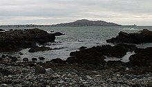
[17] Whilst most of the coastline is rocky, there are sandy beaches at Trearddur Bay and Penrhos Country Park.
The coastal zone between the island and the mainland of Anglesey is a large site of special scientific interest: Beddmanarch–Cymyran.
The Stanley Embankment also carries the North Wales Coast Line which terminates at the island's only railway station, in Holyhead.
Many people staying on Holy Island do so short term whilst waiting for the ferries to Dublin Port.
Centred in Holyhead but dotted around the island (especially Trearddur Bay and Rhoscolyn) are quite a number of smaller bed and breakfast hotels and caravan parks for people who may wish to stay longer.
Attractions in the area include South Stack Lighthouse and the RSPB reserve close by, the Breakwater Country Park,[24] the RNLI museum and walks up Holyhead Mountain.