Holyoke Range
It is also notable for its unique microclimate ecosystems and rare plant communities, as well as significant historic sites, such as the Mount Holyoke Summit House and the Horse Caves.
[9] The Holyoke Range, located within the towns of South Hadley, Hadley, Granby, Amherst, and Belchertown, rises steeply between 300 feet (91 m) and 1,100 feet (335 m) above the Connecticut River Valley below; it has an east–west orientation and is roughly 9.5 miles (15.3 km) long by 2.5 miles (4.0 km) wide at its widest point, although the steepness of the terrain makes the actual square mileage much larger.
More settlers arrived after the war ended with the defeat of the Native Americans, and by the early 19th century, most of the region's current towns had been established, and most of the land had been cleared of trees to make room for farms.
A 2004 ecological resource study conducted for the National Park Service suggests that the Metacomet Ridge may have remained more-or-less forested (cleared only intermittently) throughout New England's agricultural period, thereby allowing the area to retain its biologic diversity through the 20th century.
[1] Increasing urbanization and industrialization in 19th-century New England resulted in an opposing aesthetic transcendentalist movement characterized by the paintings of the Hudson River School of American landscape painters such as Frederic Edwin Church and Thomas Cole (who, in 1836, famously painted the Connecticut River from sketches he made from the summit of Mount Holyoke), the work of landscape architects such as Frederick Law Olmsted, and the writings of philosophers like Henry David Thoreau and Ralph Waldo Emerson.
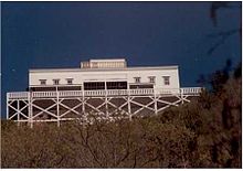
Local entrepreneurs John and Frances French were the primary owners; between 1851 and 1900, the hotel and property were subject to a number of upgrades and related construction projects including a covered tramway to the summit of the mountain (first drawn by horse, then mechanized), a railroad from the base of the mountain to a steamboat dock on the Connecticut River, and the construction of a number of outbuildings and trails.
With passenger steamship to the connecting summit railway established, the Mount Holyoke "Prospect House" became a popular tourist destination.
The summit house suffered from storm damage and lack of maintenance until the mid-1980s, when it was renovated as a museum through local volunteer efforts supported by the Commonwealth of Massachusetts.
[23] While this southern part of the Massachusetts' Pioneer Valley is the second-largest metropolitan region in the state, areas of it are economically depressed with Holyoke's average 2017 annual household income ranked at $14,000.
[24] Meanwhile, the towns of Northampton and Amherst to the north are home to many worker cooperatives and small businesses that often manufacture or sell natural products (such as tofu) to a more affluent population.
[25][26] The ridge of the Holyoke Range was formed 200 million years ago during the late Triassic and early Jurassic periods and is composed of traprock, also known as basalt, an extrusive volcanic rock.
Basalt is a dark-colored rock, but the iron within it weathers to a rusty brown when exposed to the air, lending the ledges a distinct reddish appearance.
The basalt ridges are the product of several massive lava flows hundreds of feet deep that welled up in faults created by the rifting apart of North America from Eurasia and Africa.
Backslope plant communities tend to be more similar to the adjacent Berkshire plateau containing species common to the northern hardwood and oak-hickory forest types.
Eastern hemlock crowds narrow ravines, blocking sunlight and creating damp, cooler growing conditions with associated cooler-climate plant species.
Because the traprock ridges generate such varied terrain, they are the home of several plant and animal species that are state-listed or globally rare,[1][28] such as the timber rattlesnake.
[13] In response to a proposed suburban development on the Seven Sisters part of the range in the late 1990s, several non-profit groups and local governments worked together to block construction and acquire the ridgeline for the Skinner State Park.