Hauran
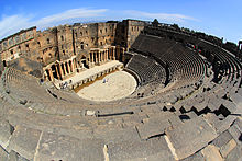
Hauran towns such as Bosra, Qanawat, Shahba, Salkhad, Umm al-Jimal and numerous others contain Roman temples and theaters, Byzantine-era churches and monasteries, and forts, mosques and bathhouses built by successive Muslim dynasties.
Its western limits are the chain of villages on the Hajj road, from Ghabaghib as far south as Ramtha ... Hauran comprises therefore part of Trachonitis and Iturea, the whole of Auranitis, and the northern districts of Batanea.
[1] During the Hellenistic period beginning in the mid-4th century BC, the Hauran was at first a possession of the Ptolemaic dynasty,[2] which saw the region as a buffer zone separating their kingdom from Seleucid Damascus.
[1] By the end of the 2nd century BC, Seleucid control of the Hauran had become largely nominal and the region became a contested area between the Nabataean Kingdom, the Jerusalem-based Hasmonean dynasty and the Iturean principality based in the northern Golan and southern Mount Lebanon.
[18][17] By 63 BC the Roman Empire extended its influence to all of Syria and initially charged local princes with keeping order in Auranitis (Jabal Hauran), Batanea (Nuqrah) and Trachonitis (Lajat).
[29] Between the late 1st and 5th centuries, several underwent urbanization and became cities, including Qanawat (Canatha), al-Suwayda (Dionysias), Shahba (Philippopolis), Shaqqa (Maxmimianopolis), al-Masmiyah (Phaina) and Nawa (Naveh).
[29] Among the inhabitants were Roman army veterans who upon returning to their villages in the Hauran invested money in land, houses, tombs, temples and public buildings and filled high-ranking local positions.
[29] Though the particularly wealthy and army veterans engaged in Hellenistic activities, such as visiting theaters and bathhouses, much of the population held on to Arab and Aramaic traditions and worshiped their native gods.
[1] During the 4th and 5th centuries, when direct imperial rule was weakened and nomadic groups overran the Sinai and the Euphrates valley, the Byzantines turned to certain powerful Arab tribes to maintain internal order and guard the Hauran.
[36] Settlement within the Hauran continued and in some cases "thrived" in the early Islamic period, with "no perceptible change in activity or cultural patterns under the Umayyad caliphs", according to historian Moshe Hartal.
[38] During this period, the large Arab tribe of Banu Uqayl, formerly allies of the Qarmatians, migrated to the Syrian steppe extending from the Hauran northward to Upper Mesopotamia.
[38] The villages of Hawran and Bathaniyya were rehabilitated by Abu Mahmud Ibrahim, the nominal Fatimid governor of Damascus, in the early 980s, after the damage inflicted on the area by the Fazara and Murra.
[1] In the early 12th century, the entire Hauran was assigned by the Burid emir of Damascus to the Turkish general Amin al-Dawla Kumushtakin as an iqta (fief), which he held until his death in 1146.
[42] Under the Mamluks, the region's strategic importance stemmed from its position on the barid (postal route) between Gaza and Damascus and Bosra's role as a major marshaling point for the Hajj caravans going to Mecca.
[44] The Hauran had long been a major grain-producing region and officially, its land belonged to the Ottoman state and its inhabitants were required to pay taxes and be conscripted into the army.
[47] According to historian Linda S. Schilcher, This hinterland political system had its own internal checks and, of course, its strains, but it appears to have existed with a fair degree of equilibrium for a very long period of time.
The low pressure of population on the land and the natural economies that existed between steppe and cultivated plain and between town and countryside appear to have contributed to this relatively stable situation.
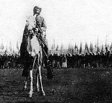
[54] During the final years of the decade-long Egyptian administration of Syria, the Druze of Jabal Hauran launched their first revolt against the authorities,[55] in response to a conscription order by Ibrahim Pasha.
[51] Thus, by the start of the 19th century, the northern plains contained several full or half-empty villages, while the south had been all but deserted, with the exception of the larger towns of Daraa (Adhri'at), Bosra and al-Ramtha.
[42] Following the crushing of the Great Syrian Revolt, which began in the Hauran, the area experienced increased prosperity and security, as its inhabitants were now protected from incursions by Bedouin tribes.
Moreover, the region's economic potential has been curtailed by the creation of international borders and the Arab–Israeli conflict, which have separated it from previously interdependent areas that are located today in Israel, Lebanon and Jordan.
[73] Thus, the region was not as affected by the Agrarian Reform Law passed in 1958 during the United Arab Republic period (1958–1961) and enforced by the Ba'ath Party government in 1963, which effected land redistribution and mostly targeted large landowners.
[76] Its principal city, Daraa, is a major transit hub for commercial traffic between Syria, Jordan, Saudi Arabia and Turkey, as well as for smuggled goods between these countries.
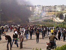
[76] The Syrian Civil War was sparked in the Hauran town of Daraa on 6 March 2011 when anti-government demonstrations were organized in response to the detention and alleged torture of a group of teenagers by the local branch of the security forces.
[77] As the revolt spread in the Hauran, anti-government forces utilized their clan networks that extended to Jordan and Arab states of the Persian Gulf, smuggling funds and weapons to sustain the rebellion.
[76] During the course of the war, they formed loosely-coordinated rebel militias, fighting under the banner of the Free Syrian Army-affiliated Southern Front, which claimed it had the allegiance of some fifty armed groups with a collective strength of 30,000 fighters.
[81] By the end of the following month, the entire Hauran was under government control, including a pocket of territory in the Yarmouk basin that had previously been held by the Islamic State of Iraq and the Levant (ISIL).
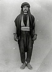
[42][82] In addition to the indigenous Ḥawarna, the plains are also populated by communities of former Bedouin tribes who gradually became settled, and Circassians who arrived over fifty years prior to the end of the 19th century.
[78] The social structure of the Hauran plain is characterized by networks of large extended agrarian clans,[82][77] such as the Hariri, Zu'bi, Miqdad, Abu Zeid, Mahamid, Masalma and Jawabra.
[10] In the words of 20th-century archaeologist Howard Crosby Butler, There is no other country in the world where the architectural monuments of antiquity have been preserved in such large numbers, in such perfection, and in so many varieties as in North Central Syria [the Dead Cities] and in the Hauran.