Hout Bay
They also hunted and fished using hooks fashioned from bones and nets made from fibrous plants and the skins of animals.
The Khoi traded with the early voyagers from Europe who were on their way to the East and had stopped at the Cape in order to get fresh food and water.
The Khoi bartered with these early sailors exchanging cattle and sheep for small pieces of copper, brass and tin.
[citation needed] Recorded in the Rutter (Logbook) by the pilot, John Davis: "Chapman’s Chaunce hath in latitude 34-10 and is a harbour which Leith within the south-west point under a little hill like charring cross (a sculptured memorial of a cross on an ornamental mounting in London) close hanging by the seaside of the S.S.W side of the land " Chapmans Chaunce was the first name given to Hout Bay and it was also the first English name to appear on the maps of Southern Africa.
[citation needed] In 1614 an English sailor records having taken wood from the forest of Hout Bay in order to mend his ship.
[citation needed] When the Dutch established a colony in Table Bay in 1652, a great quantity of good timber was required for construction, shipbuilding and other purposes.
It was soon apparent that the colonists would be able to fell wood they needed in the wetter valley that lay on the other side of a low pass (now called Constantia Nek) between the southern end of Table Mountain and Constantiaberg.
[3] In 1662, the year when Jan Van Riebeeck left the Cape, the Boscheuwel road was extended from Kirstenbosch in a rough track over Constantia Nek to Hout Bay.
For almost 10 years the factory operated successfully exporting canned crawfish overseas and providing work for the local inhabitants.
On 31 July 1914 a leak in the acetylene gas supply caused an explosion which blew up the canning factory, killing 7 people including the owner Mr. Lucien Plessis.
Today Chapman's Peak fisheries have expanded to incorporate a fish importing business as well as retailing local catches.
The post-war fishing factories spread everywhere and at Hout Bay, the South African Sea Products Company was established.
[7] Worth and Moriz founded the environmental group Fresh Air for Hout Bay[8] to research the causes and effects of the pollution.
[15] The main informal settlement in the Hout Bay area, Imizamo Yethu, is situated within a community consisting of both affluent and middle-income citizens.
[16] Current issues between residents of Hout Bay and Imizamo Yethu are focused on service delivery for the informal settlement.
In addition to much middle-income housing for local South Africans, there are also a number of multi-million rand mansions, luxurious holiday homes and some small wine estates.
As of 2007, political differences between the Democratic Alliance and African National Congress have hampered the building of houses for the residents of Imizamo Yethu.
[20] Hout Bay is surrounded by mountains to the north, east and west and the southern Atlantic Ocean to the south.
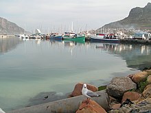
Hout Bay has one of the busiest fishing harbours in the Western Cape with an established tuna, snoek and crayfish industry.
One goes to Llandudno and Camps Bay through the pass between Judas Peak (part of the Twelve Apostles) and Little Lion's Head.
Between Hout Bay and Noordhoek, there is Chapman's Peak Drive, which was closed for many years and finally reopened in early 2004 with a controversial toll booth.
The harbour has restaurants, fresh fish outlets and craft stores, with views of the bay and boat rides to Duiker Island and around The Sentinel.
[22] The East and West forts built by the Dutch in the 18th century can also be visited, with the original cannons and barracks still standing on the slopes of Chapman's Peak.
[citation needed] The Hout Bay Yacht Club is situated in the working harbour and provides moorings for both recreational, fishing and sailing boats.
Hout Bay has several attractions, and receives a high number of visitors, especially on weekends and during peak season in the Christmas school holidays.
Swells of up to 47 feet (14.3 m) have been recorded here as well as numerous deaths as a result of boating, diving and surfing-related incidents in the area.
Before the use of jet-skis to enter and leave the area, the surfers who braved these waters had to paddle through a dark and deep channel, through to where the waves break.
[citation needed] The harbour slipway is used for boat access to the recreational dive sites of much of the west coast of the Cape Peninsula.