Houtman Abrolhos
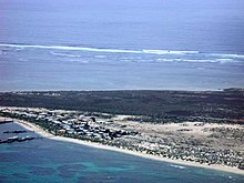
It has a small seasonal population of fishermen, and a limited number of tourists are permitted for day trips, but most of the land area is off-limits as a conservation habitat.
A spokesperson for Western Australia's Department of Primary Industries and Regional Development said that their top priority is preservation of the wildlife on the islands.
As a technical term this phytonym was later applied to caltrops (chevaux de frise), i.e. "spiked obstructions", and Portuguese sailors used the word to refer to offshore reefs.
[citation needed] The primary piece of evidence used to support the claim of Portuguese priority is the 16th century Dieppe maps, some of which are alleged to show the west coast of Australia, including an island at the position of the Houtman Abrolhos.
[26] They are first named in print in Gerritsz' 1627 map Caert van't Landt van d'Eendracht, where they bear the label Fr.
[9] The crew of Zeewijk were stranded in the Pelsaert Group for ten months, during which time they lived off seals, seabirds, eggs, and victuals salvaged from the wreck.
[9] During Admiralty surveys of the north west coast in 1840, crew from HMS Beagle discovered a brass gun of about three pounds calibre, an iron swivel on which paint still adhered as well as numerous other artefacts signifying European occupation, on the largest island in the Pelsart Group.
The commander, John Clements Wickham, named the place Gun Island and the passage between the Easter and Pelsart Groups, Zeewijk Channel.
The islands are a part of the Division of Durack in the federal House of Representatives[1] and the electoral district of Geraldton in the Western Australian Legislative Council.
[32] The Houtman Abrolhos lies almost directly in the path of the Leeuwin Current, which draws warm, low-saline water of tropical origin southwards along the coast of Western Australia.
There is limited evidence for some sporadic, localised upwelling in the vicinity of the Abrolhos, but if so it appears to have little effect on the extremely low levels of nutrients in the water.
The relatively low variability in sea temperatures at the Abrolhos is largely attributable to the Leeuwin Current, which bathes the islands in warm tropical water during winter months.
During summer a high pressure ridge lies to the south, causing persistent winds from the southeast or southwest, at speeds exceeding 8.7 metres per second (17 kn) almost half the time.
A tropical cyclone occurs in the area about once in three years, between January and April; these may generate extremely high wind speeds that are potentially destructive.
[34][35] The main biogeographic significance of the islands is their isolation, allowing them to provide refugia for such threatened fauna as tammar wallabies (Macropus eugenii), Australian sea lions (Neophoca cinerea) and rare breeding seabirds.
This is attributable to the location of the Houtman Abrolhos at the northern limit of the Southwest Shelf Transition, together with the warming influence of the Leeuwin Current.
[47] Other noxious weeds include Opuntia stricta (prickly pear),[40] Verbesina encelioides and Echium plantagineum (Paterson's curse).
[51] Only two species of land mammal are indigenous to the Houtman Abrolhos, the tammar wallaby (Macropus eugenii) and the bush rat (Rattus fuscipes).
[60] The most significant terrestrial reptile species are the spiny-tailed skink (Egernia stokesii stokesii) and the carpet python (Morelia spilota imbricata), both of which are listed as rare and therefore afforded special protection under the Wildlife Conservation Act 1950; and the Abrolhos dwarf bearded dragon (Pogona minor minima), a Houtman Abrolhos endemic that is listed as a Priority 4 species by the Department of Environment and Conservation.
Specimens of the pobblebonk (Limnodynastes dorsalis) and the turtle frog (Myobatrachus gouldii) were collected from the Houtman Abrolhos during the Percy Sladen Trust Expedition of 1913 and 1915, but no amphibians have been recorded on the islands since that time.
Historical data suggests numbers were previously much higher;[66] for example, in 1727, survivors of the Zeewyk shipwreck killed over 150 sea lions in the Southern Group alone.
In addition to direct killing of the animals, it is likely that much of the mangrove habitat on the islands was cleared as fuel for trypots, and this may have affected the survival of young pups.
As a result of this competition for light, space and nutrients, coral at the Houtman Abrolhos tends to grow more slowly and die younger than is usual.
Licensees are constrained to operate only during scallop season, which generally runs from 1 April to 30 June, and are also subject to restrictions on gear design, boat size and crew numbers.
[79] Scallop fishers mainly operate east of the Houtman Abrolhos and between the island groups, in waters deeper than 30 metres (98 ft).
The Abrolhos provides some of the best snorkelling, diving and deep sea fishing in the world, along with some of Australia's most significant historical sights, such as the shipwreck of the Batavia.
The events surrounding the loss of the Batavia is one of the most celebrated episodes in Australian popular history; in the words of Henrietta Drake-Brockman:[27] In Australia, poets and schoolboys, artists and historians, have been inspired for half a century by the tragedy of an ancient shipwreck, a disaster that piled horror upon horror yet revealed so much of human fortitude as to invite comparison with the epic tales of Greece.The story has spawned a massive body of literature, both fiction and non-fiction,[27] as well as numerous works in other media.
[citation needed] In April 2019 the Houtman Abrolhos became the site of the failure of reportedly one of Australia's biggest drug smuggling operations, worth $73 million.
[87] In 2020 a Western Australian man briefly established the Houtman Abrolhos Micro Nation, based on Uncle Margie Island.
[88] The self-declared 'prince' represented himself in the four-day trial in 2023 and relied on a bevy of pseudolegal claims to challenge the Department of Primary Industries & Regional Development (DPIRD).