Humboldt County, Iowa
[5] However, an error omitted the lower four townships (Jackson, Deer Creek, Badger, and Newark) from returning to Humboldt County.
In his decision, Chief Justice Ralph P. Lowe wrote, "We are compelled to conclude that township 90, in ranges 27 to 30, west of the 5th principal meridian, is still in and forms a part of Webster county.
Of course we can pay no attention to conjectural surmises and vague suspicions, which have been made and entertained in relation to some unfairness which may have been practiced in the final passage of the act of 1857, creating the county of Humboldt.
"[8] The "vague suspicions" include a rumor that John Duncombe of Fort Dodge (namesake of Duncombe, Iowa and plaintiff in the lawsuit) had tricked Humboldt County into ceding the southern four townships to Webster County "on loan", or was otherwise responsible for the "error".
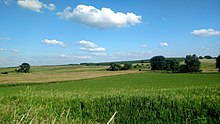
[12] Humboldt County is located entirely within the Des Moines Lobe of the Western Corn Belt Plains ecoregion, as defined by the United States Environmental Protection Agency (EPA).
One of the flattest regions in Iowa, the Des Moines Lobe ecoregion is a distinctive area naturally defined by Wisconsin glaciation but modified by humans for extensive agriculture.
In general, the land is level to gently rolling with some areas of relief defined by glacial features like moraines, hummocky knobs, and kettles, and outwash deposits.
The stream network is poorly developed and widely spaced, with major rivers carving valleys that are relatively deep and steep-sided.
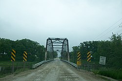
The East and West Forks of the Des Moines River merge at Frank Gotch State Park in southern Humboldt County.
The eastern part of Humboldt County is within the Boone River watershed, a tributary of the Des Moines.
The park is near his childhood farm and is also home to the confluence of the East and West Forks of the Des Moines River.
The park features campgrounds and a well-known converted railroad bridge used by the Minneapolis and St. Louis Railway.
The bridge is part of the Three Rivers Trail, a converted rail route that runs from Eagle Grove west to Rolfe.
The area can be used for camping and also has access to the Rutland Dam and West Fork of the Des Moines River.
Further downriver near Humboldt is Oxbow Park, which contains boating access ramps and much scenic open space.
Continuing along the river, the Lake Nokomis area begins, popular for its woods and small ponds.