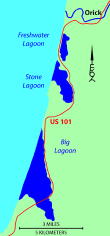
Humboldt Lagoons State Park
The lagoons are shallow bays between rocky headlands where coastal wave action has formed a sandy bar separating each lagoon from the ocean.
[2] The lagoons are resting areas for migratory waterfowl using the Pacific Flyway between Lake Earl on the Smith River estuarine wetlands 40 miles (64 km) to the north and Humboldt Bay on the Mad River estuarine wetlands 30 miles (48 km) to the south.
Studies around Humboldt Bay indicate tectonic activity along the Cascadia subduction zone has caused local sea level changes at intervals of several centuries.
[3] The alluvial plain forming each shallow lagoon may support freshwater wetlands or Sitka Spruce forests following uplift events and salt marsh or inundated shellfish beds following subsidence events.
Dry Lagoon is presently a wetland representing natural conditions of similar land used for a sawmill near Big Lagoon, or converted to agricultural purposes around the estuaries of Redwood Creek to the north and Little River to the south.