Ightham
Ightham is not mentioned in the Domesday Book, but place-name evidence implies the name is derived from the Saxon 'Ehtaham'.
[2] The earliest trackway crossing the parish runs mainly as a ridgeway on top of the North Downs from East Kent to Salisbury Plain.
Oldbury was in the centre of a series of forts running 70 miles from Holmbury in Surrey to the west to Bigberry near Canterbury to the east.
Benjamin Harrison of Ightham excavated the site of a tile works and possible Roman villa at Patchgrove Wood on the northwest edge of Oldbury Hill, close outside the parish.
A war memorial was erected in their honour opposite the George and Dragon and unveiled on 5 December 1920 by Major General Sir William Furse.
During the Blitz in 1940-41 Ightham was directly under a route then by German bombers and rocket on their way to attack London.
There are still a number of cob trees in and around the village, but the work of pruning them and picking the nuts is labour-intensive, and the industry has fallen into decline.the local school has a cobnut as its logo.
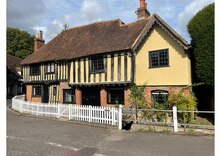
It also has a Scout group 1st Ightam scouts There were three Manor buildings House's in the original parish - the St Clere estate, Ightham Court (Court/Ightham Lodge) and Ightham Mote in the far south of the parish, at the northernmost Kent Weald.
At the end of the 1400s the parish consisted of the village centre, several hamlets and a large number of dispersed farms.
The highest point of the ancient parish in the north was near Drane Farm at over 700 feet above sea level.
Along the length of the Vale runs a band of Gault, blue-grey clay, a mile wide with some alluvial deposits.
The place of birth of residents was 91.9% United Kingdom, 0.5% Republic of Ireland, 2% other Western European countries, and 5.6% elsewhere.
[3] The economic activity of residents aged 16–74 was 38.2% in full-time employment, 11.6% in part-time employment, 14.7% self-employed, 1.9% unemployed, 1.9% students with jobs, 3.5% students without jobs, 13.9% retired, 11.2% looking after home or family, 1.1% permanently sick or disabled and 1.9% economically inactive for other reasons.
The industry of employment of residents was 12.3% retail, 9.4% manufacturing, 7.2% construction, 18.3% real estate, 8.2% health and social work, 8.3% education, 4.3% transport and communications, 3.2% public administration, 4.3% hotels and restaurants, 17.9% finance, 1.3% agriculture and 5.3% other.
Compared with national figures, the ward had a relatively high proportion of workers in finance and real estate.