Ilhabela
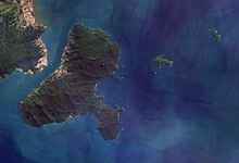
Ilhabela (Portuguese for Beautiful Island) is an archipelago and city situated in the Atlantic Ocean six kilometres (4 miles) off the coast of São Paulo state in Brazil.
It, the other islands (Búzios, Pescadores and Vitória) and the islets (Cabras, Castelhanos, Enchovas, Figueira, Lagoa and Serraria) make up the municipality of Ilhabela.
They carried out a number of attacks against Portuguese ships and settlements (namely Santos, São Vicente and Bertioga), which cost Portugal several quantities of gold and other precious stones until the 17th century.
The latter was accompanied by John Davis,[9] who had sought shelter in the island following a defeat in Vitória, Espírito Santo, only to lose even more men in a battle against the Portuguese.
According to accounts from that time, some enslaved Africans managed to flee and established the first quilombos in the region, in distant areas of dense forests.
[11] Between the 17th and 18th centuries, São Sebastião village was an important port to outflow gold found in areas now within Mato Grosso do Sul and Goiás.
The placing of these structures may have contributed to the establishment of the first white settlements in the area, still in the 17th century, which happened simultaneously to more sesmarias grants by the Portuguese.
[11] Around that time, and also because of prosperous mining activities, the first whaling station of the Captaincy of São Paulo was built in Ponta das Canavieiras.
It was believed to have focused on the local demand and that the facilities were granted by the Portuguese crown via a system under which the whaling station owners would invest in equipment and gear and, after ten years, everything would be claimed by the royal treasure.
[11] The Captaincy of Rio de Janeiro restricted olive oil ships in its waters, believing that the northern coastline of São Paulo was actually devoted to gold smuggling.
[12] Showing increasing political, social and economical relevance, due to the boom in agricultural and commercial activities, São Sebastião Island was promoted by António José da Franca e Horta (who governed São Paulo at that time) in 1805 to village status and was then renamed as "Villa Bella da Princesa" ("Beautiful Island of the Princess").
[12] Throughout the 19th century, activities concerning sugarcane began to decay, but they were soon replaced by coffee, following a trend seen around the rest of the Paraíba Valley.
Production concentrated in Ponta do Boi, in the south part of the island, more precisely at Nossa Senhora das Galhetas, Figueira e Sombrio Farm.
Growing coffee resulted in an even more intense deforestation than that caused by sugarcane, and the plants could be cultivated in altitudes higher than 500 meters, by the main island's escarpments.
There were 225 farms in which 1775 enslaved people were forced to work; the village's production around that time was greater than that of any coastal municipality of São Paulo.
[13] The locals themselves would take the products to the port in canoes known as "vogas"; the knowledge to build them was inherited from the indigenous peoples who inhabited the area in the past.
The São Paulo Geographical and Geological Commission left the following account on these boats:[13] It's the so called 'vogas' with two masts and a crew of six or more people that do this trip.
There's everything on board: lemons, coconuts and other fruits, goatlings, turkeys, hans, ducks, egs, mats and clay objects, well, an infinitude of diverse products, which are sold by the owner who trusted them to the canoe boss.
By the 1920s, Japanese immigrants settled in the island ad brought international technologies; simultaneously, the arrival of the motor boat and surrounding nets gave local fishing activities a boost, since they were previously restricted to where traditional methods functioned efficiently.
[23] The islands possess no medical structures and locals depend on the periodic visits of team sent by the city hall, comprising doctors, nurses, dentists and psychologists.
[26] Ilhabela is home to endemic species such as the Giant Atlantic tree-rat,[25] the serpents Siphonops insulanus and Liotyphlops caissara and tegus (Tupinambis merianae sebastiani and Tupinambis merianae buzionensis, the latter is endemic to the Búzios island),[27] also being a point of observation of 66 bird species exclusive to the Atlantic Forest (five of them considered globally endangered in 2015).
The first dates back to 1562, when José de Anchieta wrote in a letter to King Sebastian that the island was deserted, but contained "many tigers" (Portuguese explorers were more familiar with African and Asian animals, which they would use as parameters).
[28] Finally, it is known that in 1912 the São Paulo Geographical and Geological Commission registered one particular place with the name "Pedra da Onça" (Jaguar Rock).
[29] 2015 research by Fundação Florestal showed that, although the quality of water around is good due to the dense forests, it may be affected by intense tourism and the presence of caiçara communities lacking proper sewer systems.
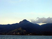
The high mountains that form the territory of the main island function as a wall against clouds, forcing them to go up and allowing for the condensation of steam and causing orographic rains.
[48] Starting from Castelhanos and going counterclockwise, the beaches are: The municipality's economy is based on tourism, commerce and civil construction, with fishing, handicraft and public service coming as secondary economical activities.