Padang
Save for several interruptions of British rule, Padang remained part of the Dutch East Indies as one of its major cities until Indonesian independence.
[10] In 1906, Padang, along with Palembang, became the first populated places in Sumatra to achieve city status (gemeente).
[11] During the 16th and 17th centuries, pepper was cultivated and traded with India, Portugal, the United Kingdom, and the Netherlands.
Boats moored in the Arau river ended up on dry land, including a 200-ton sailing ship which was deposited about 1 kilometre upstream.
The shaking caused considerable damage in Padang, and due to the tsunami boats moored in the Arau river broke their anchors and were scattered.
[13] Subsequently the city became a gemeente area since 1 April 1906 after the issuance of an ordinance (STAL 1906 No.151) on 1 March 1906.
Until World War II, Padang was one of the five largest port cities in Indonesia, apart from Jakarta, Surabaya, Medan, and Makassar.
Upon the entry of the Japanese army on 17 March 1942, Padang was abandoned by the Dutch due to their panic.
Since this tropical rainforest climate is more subject to the Intertropical Convergence Zone than the trade winds and cyclones are very rare, it is equatorial.
Padang beach (known as Taplau or Tapi Lauik) which located from Samudra Street until Puruih, is known for its sunsets and food stalls.
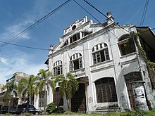
The old city was the former business district of Padang, there are many important buildings such as Padang City Hall, De Javasche bank (present-day Bank Indonesia), Nederlandsche Spaarbank, Geo Wehry & Co, Escompto Maatschappij Office, warehouses, and merchant houses.
There are several historic places such as Adityawarman Museum which specialises in the history and culture of the local Minangkabau ethnic group, and the main exhibits are housed within a Rumah Gadang style building.
The Mosque is located on Jalan Khatib Sulaiman, city centre of Padang.
There are great views of Padang city, Arau River and the Indian Ocean.
Bung Hatta Nature Reserve (Taman Hutan Raya Bung Hatta) is situated 18 km east of the city, with diverse flora and fauna including a few Sumatran tigers, tapirs, wild goats, bears, as well as Raflesia Gaduansi, Balangphora, and Amorphopalus.
The TransPadang bus rapid transit service was developed used Jakarta's TransJakarta system as a model, but without a dedicated lane and comfortable shelters.
The city is served by the newly opened Minangkabau International Airport in Ketaping, Padang Pariaman.
[35] In late 2013, the runway was lengthened by 250 metres so that it could accommodate Boeing 747 and Airbus A340 planes.
[36] A terminal expansion (Phase II) has been announced with the rendering already released on the Angkasa Pura 2 website.
[38] The port is the main gateway to the Mentawai islands, including Siberut, Sipora, and South Pagai.
There are also ferry connections between Padang to Jakarta and Sibolga next to Gunung Sitoli (Nias).
West Sumatra administration has secured lands for the construction of a 28-kilometres toll road between Padang and Sicincin district with about Rp.1.3 trillion ($141.7 million) investment.
[39] Railroad tracks connect Padang to Pariaman to the north, Padangpanjang to the northeast, Solok and Sawahlunto to the east.
Sibinuang and Dang Tuanku provides the trip services from Padang (Simpang Haru) to Pariaman vice versa.
The main campus is located at Limau Manis, about 12 kilometres (7.5 mi) from the centre of Padang.