Independence, California
Independence is located 41 miles (66 km) south-southeast of Bishop,[4] at an elevation of 3930 feet (1198 m).
The small town of Independence is bisected by U.S. Route 395, the main north–south highway through the Owens Valley.
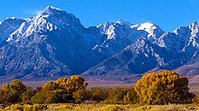
The Sierra Nevada mountains to the west lie within the John Muir Wilderness Area.
This trail takes hikers to Kings Canyon/Sequoia National Parks which protect the Sierra Nevada west of the divide between the Owens Valley on the east and the rivers which drain into the San Joaquin Valley to the west.
Independence is a popular resupply location for hikers trekking the 2,650 mile long Pacific Crest Trail which extends from the Mexican border to Canada along the crest of the Sierra Nevada and Cascade Ranges.
According to the United States Census Bureau, Independence covers an area of 4.9 square miles (13 km2), over 99% of it land.
[4] The site of Putnam's Cabin, across the street from the Inyo County Courthouse, is a California Historical Landmark # 223.
[8] Independence became the seat of Inyo County in 1866 when its chief competitor for the honor, a mining camp called Kearsarge, disappeared under an avalanche.
[4] United States Army General John K. Singlaub (1921 – 2022) was born in Independence.
[10] The Eastern California Museum with extensive collections, exhibits, and programs; is located at 155 North Grant Street in Independence.
[16] Independence is in California's 3rd congressional district, represented by Republican Kevin Kiley.