Indiana County, Pennsylvania
The Iroquois had controlled much of the Ohio River valley as their hunting grounds since the 17th century, and Anglo-American colonists were moving into the area and wanted to develop it.
Traders arranged to force the Iroquois to grant land under the treaty in relations to losses due to Pontiac's Rebellion.
They proposed that the entire large area would become a new British colony, possibly to be called Pittsylvania or Vandalia.
[5][4] Opposition from other interest groups[6] and the American Revolutionary War intervened before Britain approved such a colony.
[7] It was also in Indiana, local abolitionist leader James Moorhead published several anti-slavery newspapers.
Moorhead eventually sold the Clarion and founded a new anti-slavery paper, the Indiana Independent, which he published until his death in 1857.
In a letter to abolitionist Theodore Parker, a local geologist Peter Lesley stated there we over 3,000 men helping the railroad in the area.
[7] At least 90 county residents are known to have been conductors or agents, guiding fugitive slaves between hiding places on their way to freedom in Canada.
[14] The county has a humid continental climate which is warm-summer, (Dfb) except along the Conemaugh, from below Strangford and the Kiskiminetas River, where it is hot-summer (Dfa).
[15] Indiana County is one of the 423 counties served by the Appalachian Regional Commission,[16] and it is identified as part of the "Midlands" by Colin Woodard in his book American Nations: A History of the Eleven Rival Regional Cultures of North America.
Indiana County is also a part of the Pittsburgh-New Castle-Weirton, PA-OH-WV Combined Statistical Area (CSA), which combines the population of Indiana, as well as the Allegheny, Armstrong, Beaver, Butler, Fayette, Lawrence, Washington and Westmoreland county areas in Pennsylvania.
As of February 5, 2024, there were 48,654 registered voters across Indiana County's 69 precincts: 27,290 Republicans (56.09%); 15,193 Democrats (31.23%), 4,334 Independents (8.91%) and 1,837 from other parties (3.77%).
[27] The county is the site of the Homer City Generating Station, a coal-burning power plant.
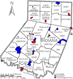
Under Pennsylvania law, there are four types of incorporated municipalities: cities, boroughs, townships, and, in at most two cases, towns.
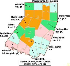
The following boroughs and townships are located in Indiana County: Census-designated places are geographical areas designated by the U.S. Census Bureau for the purposes of compiling demographic data.