Indiana Dunes National Park
Along the lakefront, the eastern area is roughly the lake shore south to U.S. 12 or U.S. 20 between Michigan City, Indiana, on the east and the Cleveland-Cliffs steel plant on the west.
The western area is roughly the shoreline south to U.S. 12 between the Burns Ditch west to Broadway in downtown Gary, Indiana.
These mounds are consistent with the period of 200 BCE (Goodall Focus) to 800 CE (early Mississippian),[3] though even that was a short lived permanency.
The remains of the town, partly carted off to be used as lumber, were located near where the pavilion in the state park now stands, until a forest fire in the 1850s destroyed whatever was left.
The Save the Dunes Council, including its president Dorothy Richardson Buell and activist Hazel Hannell, began a nationwide campaign to buy the land.
The Consolidated Appropriations Act of 2019 included the bill as a provision and was signed by President Donald Trump on February 15, creating the country's 61st National Park and the first in Indiana.
According to the United States Department of Agriculture, the plant hardiness zone at Indiana Dunes National Park at 614 ft (187 m) is 6a with an average annual extreme minimum temperature of −9.4 °F (−23.0 °C).
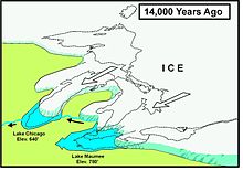
As each glacial lake breached a low spot in the moraines, water levels receded, leaving a series of shorelines and dune ridges.
The species included are:[28] Among the federally threatened and endangered wildlife are:[28] In addition, the park has habitat suitable for the bald eagle (Haliaeetus leucocephalus).
[28] Indiana Dunes National Park is host to wide variety of wildlife, including white-tailed deer, red fox, raccoons, opossums, cottontail rabbits, various rodents, Canada geese, gulls, squirrels, hawks, turkey vultures, mallards, great blue herons, songbirds, and garter snakes.
Recent records, documented photographically, indicate that North American river otter (Lontra canadensis) and bobcat (Lynx rufus) began returning to the area in 2011 and 2018, respectively.
John Francis, vice president of research, conservation and exploration for the National Geographic Society, stated that 890 species had been inventoried.
[39] The tally at the close of the 24 hours was 890 species, including 26 amphibians and reptiles, 101 birds, 18 fish, 27 fungi, 11 mammals, 410 plants, and 178 insects.
It stretches from steel plants in Burns Harbor, 12 miles (19 km) east to County Line Road on the edge of Michigan City.
As the water levels changed, new plants and trees moved in, creating a new habitat and displacing the wildlife that was dependent on the pre-existing wetlands.
The work consists of:[43] The heron rookery is located along the East Arm Little Calumet River in the northeast corner of Porter County.
As of July 2018[update], much of the dune itself, including the summit, was closed to allow beach grasses and other native plants to regenerate, and prevent injuries to visitors.
An alternative trail leading to the beach takes visitors directly past the dune, cresting just slightly lower than the summit itself.
The bog formed from a postglacial kettle moraine left behind about 14,000 years before the present by the melting of the ice sheet during the end of the last glacial period.
As of 2008[update], the park maintains a heritage farm on the Chellberg land, with the Bailly family cemetery on the northern edge of the property.
[52] The Century of Progress Architectural District is listed on the National Register of Historic Places and is located in the east portion of the park.
The district consists of a total of five buildings, all from the Homes of Tomorrow Exhibition during the 1933 Century of Progress World's Fair which took place in Chicago.
It was moved to the east side of Drake Avenue in Beverly Shores and placed atop a dune overlooking the lake.
The Schulof house located on Lakefront Drive was transferred to the Historic Landmarks Foundation of Indiana for preservation and was moved to Stephens Street in Porter.
[55] The Swedish Farmsteads of Porter County, Indiana, are representative of the numerous rural communities settled by a significant ethnic population.
[56] The park contains 15 miles (24 km) of beaches, as well as sand dunes, bogs, marshes, swamps, fens, prairies, rivers, oak savannas, and woodland forests.
The park provides opportunities for bird watching, camping, 45 miles (72 km) of hiking, fishing, swimming, horseback riding, and cross-country skiing.
[62] West Beach, located adjacent to U.S. Route 12 and County Line Road, lies on the border of Gary and Portage, Indiana.
It is a geographically separated section of the park that is preserved as a piece of public beach access and an example of the same theme of plant succession as is found in Cowles Bog.
This section of the park displays most of the successive stages of Indiana Dunes biotic progression, from open beach sands to mature Eastern Black Oak forest.