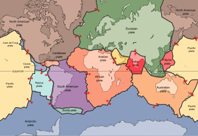
Indo-Australian plate
It contains the continent of Australia, its surrounding ocean and extends north-west to include the Indian subcontinent and the adjacent waters.
[1] The fusion happened when the mid-ocean ridge in the Indian Ocean, which separated the two plates, ceased spreading.
As the ocean floor broke apart, these land masses fragmented from one another, and for a time these centers were thought to be dormant and fused into a single plate.
New Zealand is situated along the southeastern boundary of the plate, which with New Caledonia makes up the southern and northern ends of the ancient landmass of Zealandia, which separated from Australia 85 million years ago.
[3] Contemporary models suggest at present there is a deformation zone between the Indian and Australian plates, with both earthquake and global satellite navigation system data indicating that India and Australia are not moving on the same vectors northward.