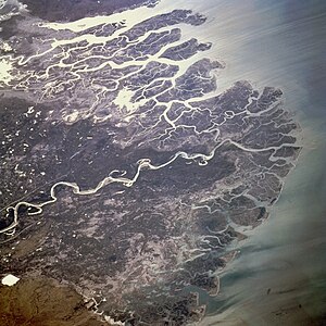
Indus River Delta
The delta is home to the largest arid mangrove forests in the world,[2] as well as many birds, fish and the Indus dolphin.
[3] As a result, the 2010 Pakistan floods were considered "good news" for the ecosystem and population of the river delta as they brought much needed fresh water.
Many former settlements in the delta have been abandoned as result of lack of water in the Indus and the encroaching Arabian Sea.
According to some accounts, the Macedonian fleet (of Alexander the Great) anchored itself for some time in the Indus river delta.
[7] According to Tarikh-i-Hind (also known as the Chach Nama) by 6th century AD there existed a port called Debal in what is now the western part of the Indus delta.
These pirates' raids against the Umayyads, and the refusal to redress the issue by the ruling prince, precipitated the Muslim conquest around 710 AD (by Muhammad bin Qasim).
By the time Ibn Batuta reached the Indus delta, Debal had been abandoned due to increased shoaling preventing the then-port from accessing the sea.
[9] When the Abbasid caliphate began to disintegrate, the delta came under the control of the increasingly autonomous province centered at Mansura.
In 1333 AD, the Samma Dynasty ruled all of the delta, and established their capital first at Samu-i (on the south bank of Keenjhar Lake) and later at Thatta.
Since 1957, the Sindh Forest and Wildlife Department has been tasked with protecting and managing 280,580 hectares (693,300 acres, estimated 45%) of mangrove-forested area of the Indus delta.
[22] This large amount of wave energy, coupled with lack of silt flowing in from the Indus river (as mentioned above), has resulted in the formation of sand beaches.
According to Haq et al., they covered an area of 600,000 hectares (1,500,000 acres) until the 1980s and could be found along the entire 240 km coastline, in 40% of the tidal zone, and in 10% of the delta fan.
Previously there had been eight species of mangroves, although only four now remain: Aegiceras corniculatum, Avicennia marina, Ceriops tagal, and Rhizophora mucronata.
[21] The 2010 Pakistan floods were considered "good news" for the ecosystem of the river delta as they brought an excess of much needed fresh water.
Karachi, Pakistan's largest city, releases sewage and discharge from industrial units into the Arabian sea, most of which is untreated.
[17] Ethnic groups of lower Sindh can be found in the delta region: Mallaah, Mohano, Soomro, Samma and Jat.
[30] In spite of this displacement and other destruction caused in the rest of Pakistan, however, many people in the delta considered the floods as "good news".
Fruits such as coconut, mango, fig, pomegranate, apple, peach, melon, banana, guava and papaya are also reportedly grown.
Electricity was previously unavailable due to high cost of establishing power lines in the difficult-to-access area.
[34] In 2010, Sindh Radiant Organization (in partnership with WWF) installed a solar-powered desalination plant developed by the Pakistan Council of Scientific and Industrial Research in the village of Jat Mohammad.
While the plant is not enough to meet the needs of the entire village, Pakistan's Ministry of Science and other NGOs have shown interest in replicating it to alleviate water shortages in the delta.
[31] Research and Development Foundation, a Pakistani NGO, has also started implementing solar desalination in six villages in Thatta with funding from Oxfam.
[35] The United Nations Economic and Social Commission for Asia and the Pacific has estimated the potential of generating 100KW of electricity by harnessing the power of tidal currents along 170 km (110 mi) of the delta's coastline.
[36] Pakistani fishermen in the delta have increasingly faced detention for accidentally straying over into Indian waters while fishing.
Because the boundaries between India and Pakistan are poorly demarcated in some areas (e.g. Sir Creek), fishermen often don't know when they've crossed the border.